
For the second week in a row, Hawaii is in the crosshairs of an intensifying tropical storm. As of 5 a.m. ET, Tropical Storm Moke was located 545 miles southeast of Hilo, Hawaii, with maximum sustained winds of 45 mph. The storm was moving to the west-northwest at 8 miles per hour.
While it is expected to remain a tropical storm and the center is predicted to pass well to the south of the Big Island of Hawaii, it will likely come close enough to bring heavy rains and gusty winds to an area just beginning to recover from the last storm.
🌀 The CNN Weather app has the latest on tropical storms
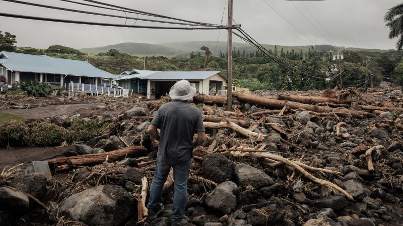
Last week, Hurricane Lala intensified while swirling just south of the Big Island. That storm dumped torrential rain — more than 3 feet in spots on the windward side of the island — that triggered damaging landslides and flash flooding that cut off small communities, destroyed homes and damaged critical infrastructure. At least one fatality has been blamed on the storm.
This devastation can be blamed in large part on El Niño. In normal years, Hawaii avoids tropical storm and hurricane damage so well it can almost feel like the islands are surrounded by an anti-hurricane force field. But that protective barrier, in the form of cooler ocean waters, is down now, and the impacts are visible for all to see.
More specifically, El Niño is helping to boost ocean temperatures to the east and southeast of Hawaii, which is where these storms tend to form and then approach the island state. It is also dramatically increasing water temperatures to the south of Hawaii as well.
In non-El Niño years, when Pacific hurricanes move west or northwest toward Hawaii, they encounter cooler ocean waters as they get closer to the islands, as well as an increase in hostile upper-level winds. These factors weaken them, since such storms get their energy from warm ocean waters and tend to thrive when the upper-level winds surrounding them are relatively weak.

The developing Super El Niño is altering both factors, most especially the ocean temperatures.
⛅ Get CNN Weather in your inbox
- The forecast is just the beginning. We’ll send you expert coverage and the stories behind the weather — so you always know more than just the number. Sign up for the newsletter
Hurricane Lala came close to making landfall on the Big Island, but the center remained just offshore of the island’s southern tip, keeping alive Hawaii’s streak of zero hurricane landfalls since Kauai was struck from the southwest by the devastating Category Four Hurricane Iniki in 1992.
However, as Hurricane Lala proved, storms do not need to make landfall on the Hawaiian Islands to cause significant damage.
El Niño also tends to significantly increase the number of storms that form in the Eastern and Central Tropical Pacific, which thereby boosts the odds that one or more of them will track near Hawaii.
Notably, El Niño has the opposite effect on the Atlantic hurricane season, where increased upper-level winds tend to shred nascent storms just as they attempt to organize and intensify. This inhibiting factor has played out so far this hurricane season, with the Atlantic going quiet for weeks on end.
Still, even during an intense El Niño hurricane season, it is not common for storms to come within 300 nautical miles of the Hawaiian Islands, according to Matthew Rosencrans, who is the lead hurricane season forecaster at the National Weather Service. He said the typical annual average for storms that come close to Hawaii is just one per season.
That means that with Moke, Hawaii will have seen twice their typical annual frequency of tropical cyclones that pass within 300 nautical miles of the state annually, and he said a third is probable at some point during this season as well.
Even during El Niño years, such close calls are not common in Hawaii, he said. He called this two-week period “very bizarre” and chalked it up to a period when the steering currents in the atmosphere have been aligned just right to get storms to head in Hawaii’s direction. This fits with the tendency for a strong El Niño to raise the odds of certain linked outcomes, without necessarily leading to more intense storms in every case.
These steering currents could change in short order, Rosencrans noted, providing a reprieve for the state.
