The regional district's emergency services branch posted to social media Monday afternoon, saying further updates will be provided as they become available.
"Water and debris from the Chilcotin River landslide is rushing downstream, and expected to cause intense, high flows and hazards in the lower Fraser River. A high streamflow advisory is in effect and regional park visitors should stay off away from the river," the post said.
"Metro Vancouver emergency management continues to monitor this emergency event closely and collaborate with partner emergency management agencies involved in the response."
The advisory is in effect for the Fraser River downstream from Hope. The distance between Hope and where the river starts to flow through the regional district is more than 100 kilometres.
River levels are expected to rise rapidly but no major flooding is expected. But flooding is only one of the risks signalled by a high streamflow advisory.
"Fast-flowing bodies of water increase risk to life safety," the province's River Forecast Centre says.
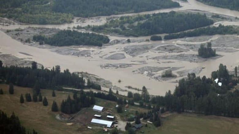
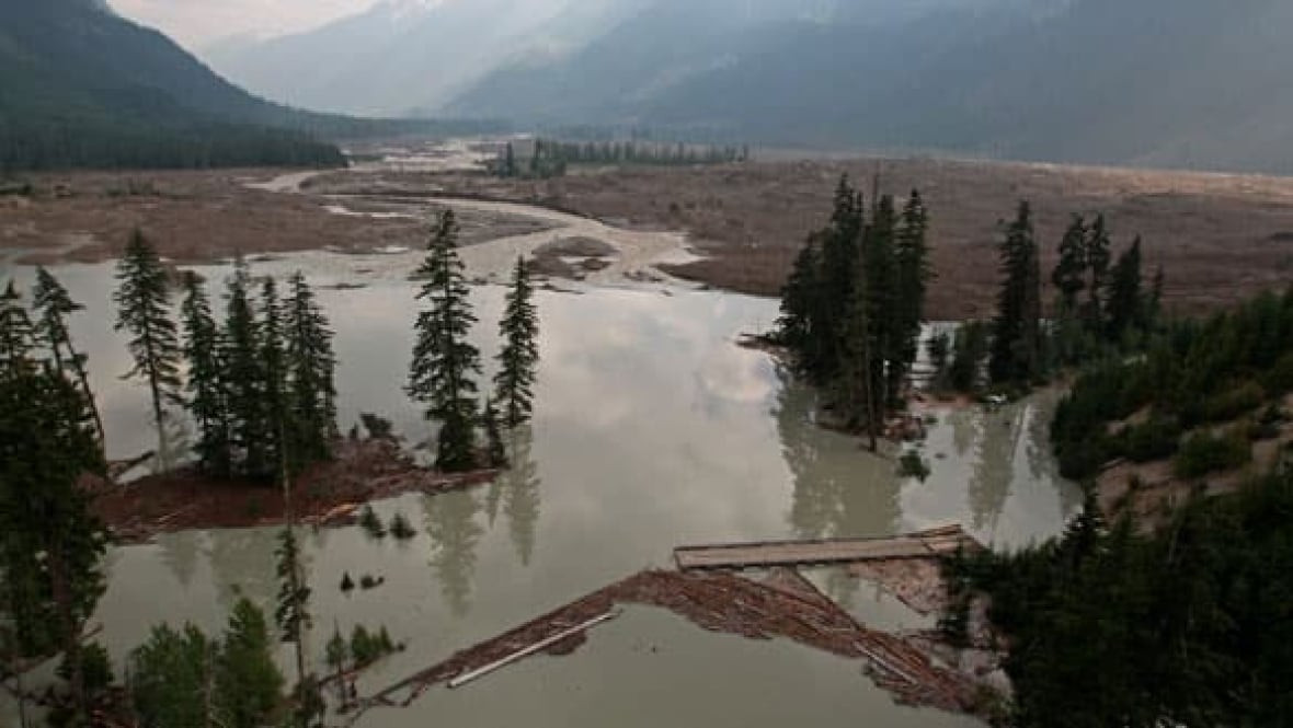
The risk of flooding is far higher further upstream, closer to where a massive landslide created a dam in the Chilcotin River that is estimated at 30 metres deep, 1,000 metres long and 600 metres wide.
Between Boston Bar and Hope, a flood watch is in effect meaning that flooding may occur, according to the province.
A flood warning is in effect for the Fraser River between the confluence with the Chilcotin River and Big Bar, which the river forecast centre explains means that flooding is all-but certain in areas in areas "adjacent" to the river.
As water continues to spill over the dam, it is expected that "significant quantities of debris and sediment will also be mobilized," the river forecast centre's warning says.
While a worst-case scenario wherein water suddenly surged through the dam instead of gradually flowing over top of it has so far been avoided, Emergency Management Minister Bowinn Ma has repeatedly urged vigilance and warned of the extreme danger associated with being on or near the rivers.
The Cariboo evacuation came on the evening of Sunday, Aug. 4 and the province issued its at 10:30 a.m. Monday, Aug. 5.
"Water has begun to overflow the landslide blocking the Chilcotin River near Farwell Canyon," the provincial government reported in an update Monday. "A B.C. Emergency alert has been issued to cellphones, radio and television to advise people in the area on or along the riverbanks of the Chilcotin River from Hanceville to the Fraser River, and the Fraser River from the Chilcotin River to the Gang Ranch Road bridge to evacuate immediately due to flooding and debris flow. People unable to evacuate themselves should call 911."
People were also told to stay off the Chilcotin and Fraser rivers and away from riverbanks due to the risk of fast-moving water and debris. "Even if the water elevation in an area may be similar to freshet (spring flooding) levels, the water will react differently, with greater momentum and force, than a gradual increase in water levels," states the advisory.
Teams are on site assessing the movement of the landslide with updates to come.
Additional B.C. Emergency alerts will be issued to people downstream on and along the Fraser River as peak flows progress.
People must follow the instructions noted in the alert.
Real-time water-level monitoring information is publicly available through the Water Survey of Canada: https://wateroffice.ec.gc.ca/
People in communities along the Chilcotin and Fraser rivers should stay up to date with their local government or First Nation regarding evacuation alerts, orders and routes to safety. This information is also here: https://www.emergencyinfobc.gov.bc.ca/
The provincial order comes after one issued by the Cariboo Regional District Sunday night.
“Due to immediate danger to life safety due to flooding caused by landslide, members of the RCMP or other groups will be expediting this action,” states Sunday's evacuation order. “You must leave the area immediately. Persons who disregard this evacuation order and remain in the evacuation order area(s) do so at their own risk. Responders may be unable to assist anyone who remains.”
Three orders were issued.
The first order applies to a 350-hectare area immediately north of the junction of the Chilcotin River with the Fraser River.
A second order applies to eight parcels in a 962-hectare area immediately south of the Chilcotin River’s confluence with the Fraser River.
The third is for the Churn Creek Bridge area, 157 hectares, including the previous evacuation alert area and a new area to the north of the confluence of the Chilcotin and Fraser Rivers.
Anyone in the order area must leave. People are being told to stay away from the Fraser River and adjacent riverbanks, as flooding and debris are expected from the Chilcotin River landslide.
Emergency Service Centre (ESS) is available. If you have been evacuated from your primary residence, call 1-250-267-4861 to access Emergency Support Services.
What do do:
The crisis comes as crews continue to battle wildfires across the province.
Government officials say the water began pouring over the blockage southwest of Williams Lake around 9 a.m. and has been picking up speed every hour since. Emergency alerts have been issued for the length of the Chilcotin and Fraser rivers and people have been asked to evacuate the water and shorelines.
“I cannot underline enough how extremely unstable and dangerous the valley is right now," Minister of Emergency Management and Climate Readiness Bowinn Ma said Monday afternoon.
River banks are expected to erode both up and downstream of the breached blockage and Ma said there is a risk of further landslides being triggered.
B.C.'s executive director of water management Connie Chapman said as of 1:30 p.m. the lake built up behind the landslide was dropping at 1.3 metres per hour and the surge of water coming out of it was travelling at about 750 cubic metres per second. That's significantly faster than the river would normally run, although lower than is seen during the spring snowmelt.
Chapman said their modelling shows the river will be about 10.5 metres higher just downstream at the Farwell Canyon bridge, dropping to 7.5 metres higher at the confluence of the Chilcotin and Fraser rivers. It's also expected to reach its peak speed there, at a projected 8,273 cubic metres per second.
The surge is anticipated to hit the Lillooet area around 1:30 a.m. Tuesday, where it will elevate the Fraser River by about four metres. By 7:30 a.m. Tuesday, Chapman said Lytton will likely be impacted, with water an estimated 3.3 metres above normal. Boston Bar is expected to see river levels rise 2.6 metres by 11 a.m. Tuesday and Hope will see water rise about one metre by around 3:30 p.m.
At each point, the water will be flowing far faster and carrying far more debris than normal.
Margo Wagner, chair of the Cariboo Regional District, said they're expecting to see rocks, trees and mud carried downstream.
The landslide, which came down on July 31, was estimated to be 1,000 metres long, 600 metres wide and 30 metres deep. Beyond the sediment contained in that mass, Wagner and Ma said further erosion of river banks will deposit even more sediment into the now swiftly moving stream.
Ma emphasized that the most important thing people can do is stay away from the rivers.
"Now is not the time to go boating. Now is not the time to go take a look at the water."
In addition to the emergency alert covering the Chilcotin and Fraser rivers in general, some properties are also under evacuation alert or order. The province said 11 properties are under order in the Cariboo Regional District. A further one property is under alert there, in addition to four properties under alert in the Thompson-Nicola Regional District.
People have also been asked to stop flying drones over the landslide site as it interferes with the work of emergency responders. A NOTAM no-fly notice has been issued for an eight-kilometre radius around the area.
-With files from Monica Lamb-Yorski