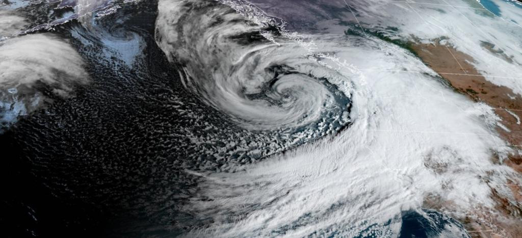
Bomb Cyclone: Pacific Northwest Braces for Historic Storm
A powerful winter storm, dubbed a "bomb cyclone," is brewing off the Pacific Northwest coast and is forecast to bring damaging winds, heavy snowfall, and torrential rain to parts of California, Oregon, and Washington. The storm, which is rapidly intensifying, is expected to unleash its fury through Friday, with some areas experiencing its impact well into the weekend. The National Oceanic and Atmospheric Administration (NOAA) has issued warnings, highlighting the significant threat of flooding, mudslides, and rockslides, especially in areas recently scarred by wildfires. The sheer volume of moisture-laden air, described by AccuWeather as a “massive firehose of rain” at lower elevations and a “giant snow gun” in the mountains, underscores the magnitude of the impending deluge.
Devastating Winds and Heavy Precipitation
Coastal regions of Northern California, Oregon, and Washington are bracing for potentially devastating wind gusts reaching up to 70 mph, starting late Tuesday and continuing into Wednesday. These ferocious winds pose a serious risk of downed trees and widespread power outages. The Weather Prediction Center, in a stark warning on X, highlighted the potential for “numerous flash floods, hazardous travel, power outages, and tree damage” as the storm reaches its peak intensity on Wednesday. The intensity of the winds and the volume of precipitation are concerning, as they will be compounded by high tides and the saturated conditions of soils from prior storms. The coastal impacts will not be limited to trees and power lines. Expect significant coastal erosion, leading to property damage and unpredictable sneaker waves that surge inland unexpectedly.
Mountainous Snowfall and Travel Disruptions
The storm is expected to drop heavy, wet snow in many of the Pacific Northwest's mountain ranges, leading to what the National Weather Service's Weather Prediction Center described on X as "whiteout conditions and near impossible travel." This is particularly true at pass level in the Cascades and northern California. The combination of blizzard conditions in the mountains and low-elevation flooding is expected to severely impact travel across the region, causing widespread travel disruptions. Specific areas like the Olympic Mountains, including Grisdale, Hurricane Ridge, Quinault, Mount Olympus, and Amanda Park, are forecast to receive 12 to 24 inches of snow accompanied by wind gusts up to 50 mph. In Northern California, areas east of Forest Glen and Hyampom, above 3,500 feet, including sections of Highway 36, are also under a heavy snow warning. Travelers are strongly urged to exercise extreme caution and be prepared for potential emergencies by having extra supplies in their vehicles, such as flashlights, food, and water.
The Science Behind the Storm: Bombogenesis and Atmospheric Rivers
This potent storm, officially classified as a "bomb cyclone," gains its destructive power through a process called bombogenesis—a rapid drop in atmospheric pressure that intensifies the storm's strength. Bombogenesis is defined by a pressure drop of at least 24 millibars within 24 hours. The lower the pressure, the more powerful the storm becomes. The term "bomb cyclone," coined in the 1940s and popularized by MIT professor Fred Sanders in 1980, aptly describes these storms' explosive intensification. The process occurs when cold air collides with warm air, such as over warm ocean waters, leading to the formation of this rapidly strengthening system. This system will be augmented by an atmospheric river. These rivers in the sky carry immense amounts of water vapor – more than the Mississippi River – and are responsible for much of the rain and snowfall in the western United States. Their presence compounds the severe weather and makes the flooding potential much greater.
The Magnitude of the Waves
The bomb cyclone's impact will extend far beyond the immediate coastline. The storm is predicted to generate swells that will travel thousands of kilometers, reaching as far as Hawaii and the western beaches of Mexico’s Baja Peninsula. These swells, unlike choppy wind-driven waves, are smoother, longer-period waves that can travel vast distances, carrying the storm’s energy across enormous stretches of ocean. Near the storm's center, where wind-driven waves meet the long-traveling swells, the seas will reach incredible heights, with significant wave heights exceeding 10 meters (35 feet) just a couple of hundred kilometers off the coast of Vancouver Island. The theoretical maximum wave height could reach a staggering 20 meters (70 feet)—the equivalent of a six-story building. Even closer to shore, the waves will remain powerful, with waves between six and eight meters (20-26 feet) expected along the west coast of Vancouver Island. Those planning to visit the coast for storm watching should exercise extreme caution and stay well back from the water. The timing of high tide, coupled with residual effects from the recent king tide cycle, adds yet another layer of risk. This combination of powerful waves and high tides will cause additional flooding and erosion along exposed coastlines.
Preparing for the Aftermath: Power Outages and Travel Disruptions
With hurricane-force winds predicted, power outages are expected to be widespread. BC Hydro is preparing for the storm by increasing its crew numbers and strategically positioning equipment to expedite restoration efforts. BC Ferries is also closely monitoring the situation and will provide updates on potential service disruptions. The storm's impact extends beyond immediate physical damage, with the potential for significant economic disruption. The October storm caused $110 million in insured damage claims in British Columbia, highlighting the substantial financial toll that such extreme weather events can inflict. Canada has already experienced over $7.7 billion in insured losses from severe weather this year, illustrating a clear need for proactive infrastructure improvements and disaster preparedness. The high winds will down power lines and trees and block roads, and the high waves will inundate coastal communities.
The potential for widespread disruption and damage underscores the need for preparedness. The government and aid organizations are bracing for a large-scale response. The long-term impact will be felt by businesses, communities and individuals for a long time to come. The storm's passage will mark the beginning of a long recovery process.


