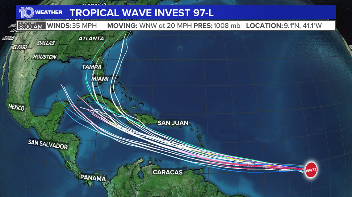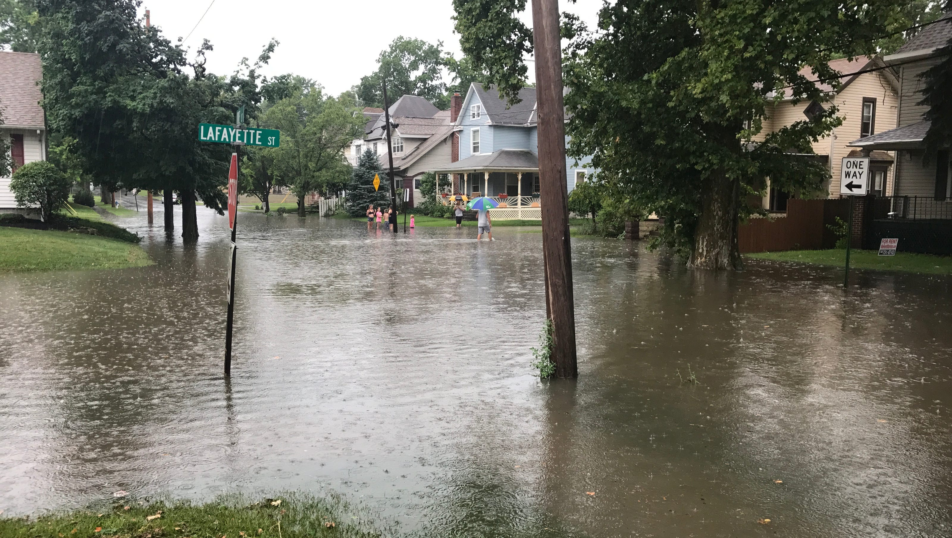
The National Weather Service issued a flash flood warning at 2:27 p.m. on Thursday in effect until 4:30 p.m. "At 2:27 p.m., Doppler radar and automated rain gauges indicated thunderstorms producing heavy rain across the warned area. Between 2 and 4 inches of rain have fallen. Additional rainfall amounts of 1 to 2 inches are possible in the warned area. Flash flooding is ongoing or expected to begin shortly," adds the NWS. "Flash flooding of small creeks and streams, urban areas, highways, streets and underpasses as well as other poor drainage and low-lying areas." Locations impacted by the warning include North Augusta, Grovetown, Evans, Waynesboro, Fort Eisenhower, Martinez, Augusta, Belvedere, Hephzibah, Harlem, Midville, South Augusta, Augusta Mall, Daniel Field, Village Plaza Shopping Center, Glendale, Augusta Regional Airport, Summerville, Midtown and Augusta National Golf Club. This includes the following highways: Interstate 520 in South Carolina between mile markers 17 and 18. Interstate 20 in South Carolina between mile markers 0 and 3. Interstate 20 in Georgia between mile markers 178 and 201. Interstate 520 in Georgia between mile markers 1 and 13. The NWS states, "Most flooding deaths occur in vehicles. Never drive through a flooded roadway or around barricades. Turn around, don't drown. Be aware of your surroundings and do not drive on flooded roads. Report any flooding directly to the Columbia National Weather Service at 803 234 4115 when it is safe to do so." The flash flood warning is just one of many weather alerts in effect for the region, as rain continues to fall across the Southeast. In Virginia, Gov. Glenn Youngkin also has issued a state of emergency in advance of the arrival of the remnants of Hurricane Helene, which is expected to track past Virginia. In West Virginia, a Flood Watch is in effect today for Monroe, Giles, Mercer, Bland, Wythe, and Tazewell counties until Friday night at 8 PM. A Flood Watch is also in effect for McDowell and Buchanan counties 8 PM Thursday. A Flash Flood Warning is in effect for Bland, Wythe, Giles, southeastern Tazewell, and southern Mercer counties until 12:30 PM. Multiple flood warnings are in effect for our area this morning as well. Bland, Tazewell, Mercer, and Wythe counties are under a Flood Warning until 8 AM. Central and eastern Giles County and southwestern Monroe County are under a flood warning until 8:15 AM. Central and eastern Monroe County is under a Flood Warning until 8:45 AM. These areas have seen lots of heavy rainfall and will continue to do so over the next several hours. The heavy rains come as the remnants of Hurricane Helene are expected to make their way through the region. According to the National Weather Service in Blacksburg, Va., between 2 to 4 inches of rain have already fallen in parts of the region. Flooding caused by excessive rainfall is expected to continue, according to forecasters. The NWS advises residents to heed all warnings and to be prepared for the possibility of flooding.
Flood Warnings: A Breakdown of What They Mean
Flood warnings, advisories, and watches are issued by the National Weather Service (NWS) to inform the public about potential or actual flood hazards. Here's a breakdown of each type of alert:
Flash Flood Warning A flash flood warning is issued when a flash flood is imminent or occurring. If you are in a flood-prone area, move immediately to high ground. A flash flood is a sudden violent flood that can take from minutes to hours to develop. It is even possible to experience a flash flood in areas not immediately receiving rain.
Flood Warning A flood warning is issued when flooding is imminent or occurring.
Flood Advisory A flood advisory is issued when flooding is not expected to be bad enough to issue a warning. However, it may cause significant inconvenience, and if caution is not exercised, it could lead to situations that may threaten life and/or property.
Flood Watch A flood watch is issued when conditions are favorable for flooding. It doesn't guarantee that flooding will occur, but it signifies that the possibility exists.
Staying Safe During Floods: Tips from the NWS Floods can pose a significant threat, especially if you live in a flood-prone area or find yourself camping in a low-lying region. To ensure your safety, the NWS offers essential flood safety guidelines:
Move to higher ground If you're in a flood-prone area, or if you're camping in a low-lying spot, move to higher ground as a first step.
Adhere to evacuation orders When local authorities issue an evacuation order, promptly comply. Before leaving, secure your home by locking it.
Disconnect utilities and appliances If time permits, disconnect your utilities and appliances. This precaution minimizes electrical hazards during flooding.
Avoid basements and submerged areas Avoid basements or rooms submerged in water with electrical outlets or cords. Preventing electrical accidents is crucial.
Evacuate promptly for safety If you notice sparks or hear buzzing, crackling, snapping, or popping noises, evacuate immediately. Avoid any water that may be charged with electricity.
Stay away from floodwaters Never attempt to walk through floodwaters, even if they appear shallow. Just 6 inches of fast-moving water can forcefully sweep you off your feet.
Seek higher ground when trapped Should you become trapped by moving water, reach the highest point possible and dial 911 to contact emergency services.
Rainy Roads Ahead: Safety Tips During Heavy Rainfall Rain can turn roads into hazards. Stay informed and follow these NWS tips to ensure safety during heavy rainfall:
Beware of swollen waterways In heavy rain, refrain from parking or walking near culverts or drainage ditches, where swift-moving water can pose a grave danger.
Maintain safe driving distances The two-second rule for following distance is your ally in heavy rain. Extend it to four seconds to ensure safe spacing in adverse conditions.
Slow down and stay cautious On wet roads, slowing down is paramount. Gradually ease off the accelerator and avoid abrupt braking to prevent skidding.
Choose your lane wisely Stick to the middle lanes on multi-lane roads to minimize the risk of hydroplaning, as water tends to accumulate in outer lanes.
Visibility matters Turn on your headlights and be careful of other vehicles to the rear and in blind spot areas as they are especially difficult to see through rain-spattered windows.
Watch out for slippery roads The initial half-hour of rain is when roads are slickest due to a mixture of rain, grime, and oil. Exercise heightened caution during this period.
Keep a safe distance from large vehicles Don't follow large trucks or buses too closely. The spray created by their large tires reduces your vision. Take care when passing them as well; if you must pass, do so quickly and safely.
Mind your windshield wipers
-
Heavy rain can overload the wiper blades. When visibility is so limited that the edges of the road or other vehicles cannot be seen at a safe distance, it is time to pull over and wait for the rain to ease up. It is best to stop at rest areas or other protected areas.
-
If the roadside is your only option, pull off as far as possible, preferably past the end of a guard rail, and wait until the storm passes. Keep your headlights on and turn on emergency flashers to alert other drivers of your position.
By following these safety measures, you can significantly reduce risks and ensure your well-being when heavy rain pours down. Stay informed about weather conditions and heed advice from local authorities to make your journey safe and sound.