Parts of Florida are now under a hurricane watch as the chance Tropical Storm Debby could be a hurricane when it makes landfall in the state increases.
The storm, which is now Tropical Depression Four, is also forecast to slow down significantly after making landfall and wring out multiple days of rain in the Southeast, increasing the chances for significant flooding there.
The hurricane watch was issued for parts of Florida’s Big Bend region, where the National Hurricane Center forecasts a landfall as a strong tropical storm by Monday morning. The area is still recovering from a devastating blow by Category 3 Hurricane Idalia last August.
Other alerts warning of tropical storm conditions over the next 48 hours span the entire western Florida coast south of the Big Bend and include Tampa, Sarasota, Fort Myers and Naples.
Tropical Depression Four currently has maximum sustained winds of 30 mph and is about 170 miles southeast of Key West, just off the coast of Cuba, according to the National Hurricane Center’s 8 a.m. ET update.
The storm is expected to enter the eastern Gulf of Mexico on Saturday and officially become Tropical Storm Debby, according to the hurricane center. Tropical storm conditions could begin Saturday night in parts of southwest Florida, and rain will start impacting parts of South Florida.
“Very Intense” rainfall is expected in Southwest Florida Saturday and a widespread 3 to 5 inches of rain could fall, according to the Weather Prediction Center. The intense rain will be potent enough to cause flash flooding, even in marshy areas of the state more capable of handling excess water.
The storm is forecast to continue to strengthen through the weekend and up to landfall while tracking through the Gulf of Mexico parallel to the western coast of Florida.
Shifts in the storm’s exact track and strength are still possible over the next 48 hours, but a key factor in the increasing chances for a hurricane is how much time the system spends over record-warm water in the eastern Gulf of Mexico.
Warm water is fuel for storms to strengthen and potentially rapidly intensify, a phenomenon becoming more likely as global temperatures rise because of fossil fuel pollution.
Forecasters shifted the storm’s track to the west and believe the storm will spend more time over water now.
“The westward shift to the track forecast now also keeps the system over the warm waters of the Gulf of Mexico longer, giving the system additional time to potentially strengthen,” the hurricane center said. “It is important to note that because of the forecast track being parallel to the west coast of Florida, the location and timing of a potential landfall cannot be pinned down at this time.”
Where and when the storm comes ashore and how strong it is at that time will affect the risk of “life-threatening” storm surge.
Up to 5 feet of storm surge is possible in parts of the Big Bend and up to 4 feet is possible from Bonita Beach north through Tampa Bay.
No matter its strength, torrential, flooding rain will be the most significant impact from the storm – especially with the system forecast to slow down after landfall.
After landfall Monday, the storm is forecast to track to the northeast over portions of northern Florida and southern Georgia.
But the atmospheric components that help steer and push storms along are forecast to breakdown and cause future-Debby to slow significantly while over the Southeast early next week.
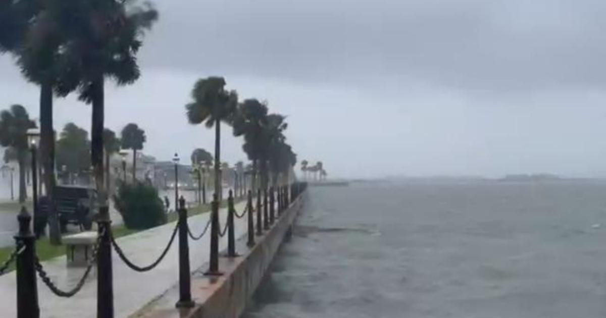
The flood threat increases dramatically with slower storms as they linger over the same areas and dump repeated bouts of heavy rain. Five to 10 inches of rain – potentially more – is forecast over coastal portions of Georgia, South Carolina and North Carolina.
As a result, the risk of flooding rainfall was increased to a level 3 out of 4 over the coasts of Georgia and South Carolina, including Savannah and Charleston, for Monday into Tuesday.
It’s also possible that this risk level will increase to a level 4 of 4 depending on the future track of the storm, the Weather Prediction Center said.
Freshwater flooding – flooding caused by rainfall – has become the deadliest aspect of tropical systems in the last decade, according to research conducted by the National Hurricane Center.
A world warming due to fossil fuel pollution is making this potential threat more dangerous. Studies also have shown tropical systems are slowing down over time, which means they’re more likely produce greater rainfall totals over a given area.
Oceans are also getting warmer and supercharging storms, pumping them full of moisture. A 2022 study published in the journal Nature Communications found climate change increased hourly rainfall rates in tropical storms by 5 to 10% and in hurricanes by 8 to 11%.
Florida Gov. Ron DeSantis has declared a state of emergency for 54 of the state’s 67 counties to mobilize resources as the storm churned toward the Sunshine State.
“Floridians are encouraged to monitor weather conditions, listen to all orders from local officials, create disaster preparedness plans, and stock disaster supply kits with food, water, and other necessities for their households,” the governor’s office said Friday.
Sandbag distribution began Friday for residents in several communities in the Orlando and Tampa metros. Multiple counties in the state’s panhandle – including Escambia, Okaloosa and Santa Rosa – started distributing sandbags Thursday.
“You still have some time to put your disaster supply kit together,” Hurricane Center Director Michael Brennan said Friday. “Make sure you have multiple days of food, water, prescription medicines. Keep your gas tank full, cash on hand, and keep batteries. Make sure your phone’s charged and make sure you have a battery powered radio.”
CNN’s Taylor Ward and Paradise Afshar contributed to this report.
© 2024 Cable News Network. A Warner Bros. Discovery Company. All Rights Reserved. CNN Sans ™ & © 2016 Cable News Network.
Sign up for the Morning Brief email newsletter to get weekday updates from The Weather Channel and our meteorologists.
Tropical Depression Four Expected to Strengthen into Tropical Storm Debby and Bring Heavy Rain and Flooding to Florida
Watches and Warnings in Effect
A hurricane watch is in effect for a part of the Florida's Big Bend, from Aucilla River to Yankeetown. Tropical storm warnings and watches cover the rest of western Florida, from the Keys to north of Tampa Bay and the easternmost Panhandle region.
A storm surge watch has also been issued for the west coast of the Florida peninsula from Bonita Beach to Aucilla River, including Tampa Bay and Charlotte Harbor. Life-threatening storm surge is possible in this area.
Tracking the Storm
Tropical Depression Four is currently centered near Cuba and traveling west-northwestward. Some of its bands of rain are already spreading as far north as southern Florida.
The latest National Hurricane Center forecast shows this system becoming Tropical Storm Debby on Saturday or Saturday night. It will then head toward a landfall in Florida's Big Bend region on Sunday night or Monday morning as either a strong tropical storm or possibly a Category 1 hurricane. It's important to note that impacts from this system will be felt across much of the Florida Peninsula, and not just where the system makes landfall.
From there, future Debby is forecast to track near the Southeast coast early next week, where it could intensify again assuming it remains over water. There is an increasing possibility this system might slow down or even stall somewhere near the Southeast coast, which could prolong impacts, especially flooding rain.
Flooding Rainfall
The system is likely to bring rainfall to Florida this weekend. Heavy rain could linger in Florida early next week while also spreading up through eastern Georgia and the eastern Carolinas. That means flash flooding and isolated river flooding are possible in all of those areas.
If this system slows down or stalls, it would prolong impacts near the Southeast coast and somewhat inland – particularly heavy rain. The slower a tropical system moves, the greater the rainfall. A study released last year by the NHC found rainfall flooding was responsible for the most direct U.S. deaths from tropical storms and hurricanes since 2013.
Rainfall totals of 5 to 10 inches (locally up 15 inches) are possible in spots across Florida and along the Southeast coast through Thursday morning, the NHC says.
Storm Surge
Coastal flooding from storm surge is possible on the western coast of Florida this weekend.
The surge could reach 3 to 5 feet above normal tide levels if the peak surge arrives at high tide in Florida's Big Bend. Most other areas could see a storm surge of 1 to 4 feet, including Tampa Bay and Charlotte Harbor.
Eventually, coastal flooding could affect the Southeast coast early next week, but it’s too early for details.
Wind and Tornado Threats
Much of the Florida Peninsula will see gusty winds at times this weekend, especially in heavier bands of rain.
Stronger wind gusts might cause some sporadic power outages or tree damage, especially near and inland from where the eventual center of the system tracks.
The Southeast coast is likely to be affected by strong winds early next week.
There is also the possibility of an isolated tornado threat in Florida this weekend.
Be sure to check back frequently to weather.com and The Weather Channel app for forecast updates in the days ahead.
More on Weather.com:
-
Hurricane Season Peak Time Begins In August
-
Why Slow-Moving Storms Are The Worst
-
August US Outlook
Your local forecast, plus daily trivia, stunning photos and our meteorologists’ top picks. All in one place, every weekday morning.
By signing up, you're opting in to receive the Morning Brief email newsletter. To manage your data, visit Data Rights. Terms of Use | Privacy Policy
We recognize our responsibility to use data and technology for good. We may use or share your data with our data vendors. Take control of your data.
© The Weather Company, LLC 2024
Tropical Storm Debby Expected to Bring Days of Flooding Rain to Florida and Southeast
A tropical storm warning has been issued and a state of emergency declared in parts of Florida in anticipation of Tropical Storm Debby – a storm that hasn’t yet formed but could unleash multiple days of heavy, flooding rainfall to the state and the southeast United States starting this weekend.
The system has 30 mph winds and has been designated Tropical Depression Four by the National Hurricane Center as it comes together over parts of Cuba and the southern Bahamas Friday. It became organized enough to be classified as a tropical depression Friday, according to the 11 p.m. advisory from the hurricane center.
The storm is expected to strengthen into Tropical Storm Debby by Saturday evening.
Tropical storm watches and warnings have been extended northward in Florida, according to the 5 p.m. ET advisory from the National Hurricane Center.
The tropical storm warning has been extended along the west coast of the Florida peninsula from Bonita Beach to Boca Grande. Meanwhile, the tropical storm watch has been extended northward from Aripeka to the mouth of the Suwannee River.
Parts of the Florida Keys and parts of the Central Florida coast are also under a tropical storm watch, with officials urging residents there to prepare for tropical storm conditions within the next 48 hours. The watch includes Fort Myers, Cape Coral and Tampa Bay.
The storm’s exact track and strength are still uncertain. How much time the system spends over record-warm water in the eastern Gulf of Mexico will determine how strong it becomes.
The storm is expected to turn to the northwest and eventually north over the weekend. However, so far the system has not begun its turn to the northwest, which has led the hurricane center to shift the forecast cone to the west.
This will allow more time for strengthening and the hurricane center shows the storm nearing hurricane strength by the time it reaches landfall in the Big Bend region of Florida Monday morning.
“The westward shift to the track forecast now also keeps the system over the warm waters of the Gulf of Mexico longer, giving the system additional time to potentially strengthen,” the hurricane center said. “It is important to note that because of the forecast track being parallel to the west coast of Florida, the location and timing of a potential landfall cannot be pinned down at this time.”
It will track parallel to Florida’s Gulf Coast for some time this weekend and strengthen as it does so, before curving east and making landfall. The system’s strength would be limited if it moves more quickly over Florida.
“Since the forecast track is almost parallel to the west coast of the Florida Peninsula and the southeast coast of the US, only a small change in the track could lead to large changes in which land areas receive any landfalls and the biggest impacts,” the National Hurricane Center cautioned Friday.
Where and when the storm comes ashore and how strong it is at that time will affect the risk of storm surge. For now, up to 3 feet of storm surge is possible this weekend along the coast from South Florida to north of Tampa Bay.
No matter its strength, torrential, flooding rain will be the most significant impact from the storm, especially if the system were to slow down, a possible scenario.
The flood threat prompted Florida Gov. Ron DeSantis to declare a state of emergency. The order was issued Thursday for 54 of the state’s 67 counties to mobilize state and local resources ahead of the storm.
Sandbag distribution began Friday for residents in several communities in the Orlando and Tampa metros. Multiple counties in the state’s panhandle – including Escambia, Okaloosa and Santa Rosa – started distributing sandbags Thursday.
A level 2 of 4 risk of flooding rainfall is in place Saturday for much of South Florida as the system organizes just off the coast, according to the Weather Prediction Center.
“Very intense” rainfall rates of 2.5 to 3 inches per hour are possible within the heaviest storms in the system’s outer rain bands Saturday, the WPC warned. Rainfall rates this potent are enough to cause flash flooding, even in marshy areas of the state more capable of handling excess water.
The risk to life and property would increase considerably if these intense storms reach the Miami area. Up to 20 inches of rain deluged South Florida in a very short window in early July and produced extremely dangerous flash flooding across the greater Miami metro, resulting in a couple hundred water rescues.
The level 2 of 4 risk of flooding rainfall will expand over much of the state and reach into other portions of Georgia and the Carolinas Sunday.
Exactly when and where torrential downpours set up outside of Florida will depend on the system’s ultimate track, but heavy rain is possible as early as Sunday afternoon. It’s also possible that this risk level will increase – especially in Florida – once the system’s track comes into further focus.
Heavy rain will continue to pound parts of the Southeast early next week, especially if, instead of tracking steadily along the Florida Gulf Coast and making landfall, the system slows down and stalls over one region – potentially around Florida’s Big Bend.
Rainfall totals of 4 to 8 inches are possible through Monday over much of Florida and the coasts of Georgia and the Carolinas. But if the system happens to stall, rainfall totals could increase dramatically.
Freshwater flooding – flooding caused by rainfall – has become the deadliest aspect of tropical systems in the last decade, according to research conducted by the National Hurricane Center.
A world warming due to fossil fuel pollution is making this potential threat more dangerous. Studies have also shown tropical systems are slowing down over time, which means they’re more likely produce greater rainfall totals over a given area.
Oceans are also getting warmer and supercharging storms, pumping them full of moisture. A 2022 study published in the journal Nature Communications found climate change increased hourly rainfall rates in tropical storms by 5 to 10% and in hurricanes by 8 to 11%.
CNN’s Sara Smart contributed to this report.
For more CNN news and newsletters create an account at CNN.com
The latest breaking updates, delivered straight to your email inbox.
Tropical Depression Four Strengthens and Heads Toward Florida
The National Hurricane Center announced late Friday that PTC Four has been upgraded to a tropical depression and is heading toward Florida.
In its 5 a.m. advisory, the NHC said Tropical Depression Four formed off the south coast of Cuba and is expected to become a tropical storm over the Southeastern Gulf Of Mexico by late Saturday. It's moving toward the west-northwest near 16 mph.
A turn toward the northwest is forecast today, followed by a northward motion on Sunday and then a slower northeastward motion Sunday night and Monday.
Areas in Florida could see up to 15 inches of rain, the NHC said.
The tropical depression holds winds of 30 mph and a central pressure of 1009 mb. If winds increase, the storm will be named Debby.
On Friday, models showed a shift to the west coast of Florida, and landfall could happen somewhere in the southwest region.
Tropical Storm Warnings and Watches Issued
A tropical storm warning is in effect for the the Dry Tortugas and has been extended northward along the west coast of the Florida peninsula from Boca Grande to south of Yankeetown, including Tampa Bay and Sumter County.
A tropical storm watch is in effect for:
- The Florida Keys
- The west coast of the Florida peninsula from north of Yankeetown to the mouth of the Suwannee River
- Parts of the Central Florida coast
- Parts of the Panhandle
A hurricane watch is in effect for the Aucilla River to Yankeetown.
A storm surge watch has been issued for the west coast of the Florida peninsula from Bonita Beach northward to the mouth of the Suwannee River, including Tampa Bay and Charlotte Harbor.
A tropical storm warning means that tropical storm conditions are expected somewhere in the warning area within 36 hours.
A tropical storm watch means that tropical storm conditions are possible in the watch area over the next 48 hours.
Potential for Flooding and Severe Storms
The system is expected to dump plenty of rain on Florida, but the exact timing of those impacts is still unknown. Currently, models show rain starting on Sunday and lasting until almost midweek. However, this could change depending on the speed and intensity of the system.
With the new model data and Central Florida's possible proximity to the center of the storm, First Warning meteorologists are tracking the elevated threat for tornadoes.
Chief Meteorologist Tony Mainolfi said he's monitoring another wave coming off the west coast of Africa.
Stay with WESH 2 online and on-air for the most accurate Central Florida weather forecast.
Download the WESH 2 News app to get the most up-to-date weather alerts.
The First Warning Weather team includes First Warning Chief Meteorologist Tony Mainolfi, Eric Burris, Kellianne Klass, Marquise Meda and Cam Tran.
Hearst Television participates in various affiliate marketing programs, which means we may get paid commissions on editorially chosen products purchased through our links to retailer sites.