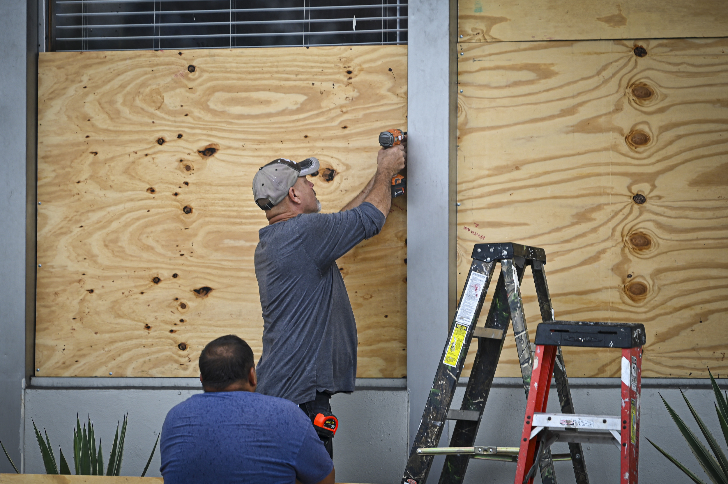
Florida is bracing for “unsurvivable” storm surge as Hurricane Helene is expected to strengthen into a Category 4 storm before making landfall later today. Just over a month after Storm Debby hurtled into the Sunshine State, Hurricane Helene now threatens to become the strongest storm to hit the US in over a year. It is expected to make landfall near Florida’s Big Bend region late on Thursday.
Hurricane Helene, currently a Category 2 storm, has 105mph winds as of Thursday morning, with sustained winds potentially building up to 135mph. Florida officials are warning residents to brace for life-threatening rain, floods and storm surge.
Florida Governor Ron DeSantis declared a state of emergency on Tuesday, and several areas remain under hurricane warnings. Florida’s Big Bend will see the worst of the storm surge, with up to 20ft possible this week.
On Wednesday, Florida Senator Rick Scott told residents that those in the path of the storm surge won’t survive.
“In the Big Bend, they’re talking about possibly 18ft of storm surge,” Scott said in Taylor County. “I’m a little over six feet — that’s three times my height. None of us are living that....You’re not going to survive.”
Tucker Carlson’s live event at the Bon Secours Wellness Arena in Greenville, South Carolina, which was set for Thursday evening has been cancelled due to Hurricane Helene.
The show, aptly named Tucker Carlson Live 2024, promised an “interesting and fun as hell” night as the former Fox News presenter was set to be joined with firebrand Republican lawmaker Marjorie Taylor Greene.
Instead of watching Carlson chat with the Georgia representative, those who purchased tickets to the Greenville leg of Carlson’s first live tour will receive a refund.
Just moments after appearing live on Fox News, Ron DeSantis said at a press conference that “nobody in recent memory has seen a storm of this magnitude,” in northern Florida.
The Florida Governor made the remarks ahead of Hurricane Helene, which is now a Category 2 storm, reaching Florida’s Gulf Coast which is expected to happen later today.
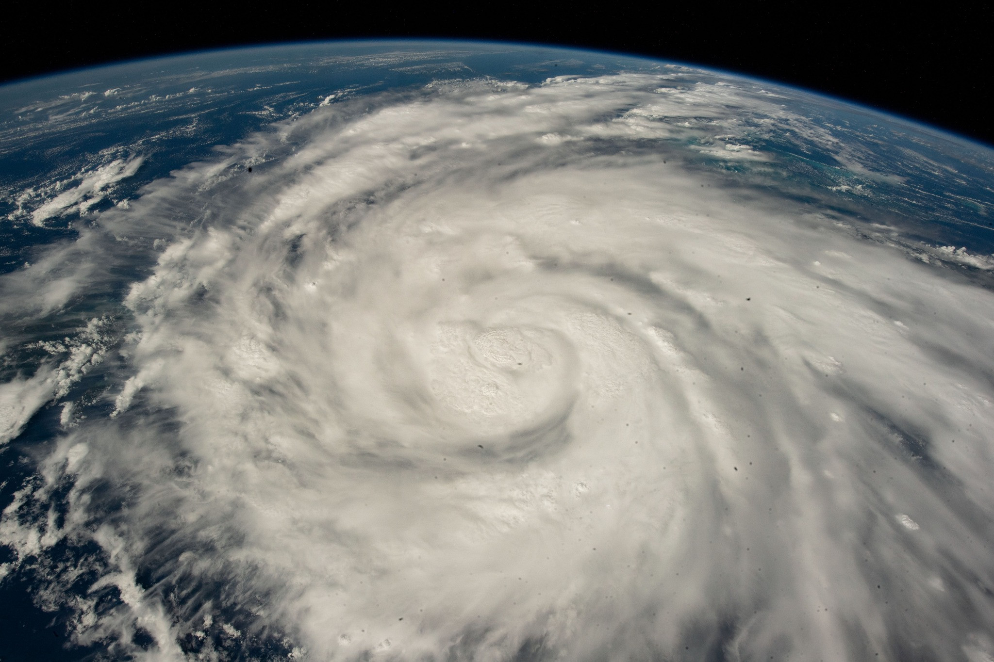
One Helene makes landfall, it is possible that it could again be upgraded to a near-Category 4 hurricane, with sustained winds in excess of 130mph, aoccrinding to the National Hurricane Center.
Floridians are currently bracing for catastrophic winds and storm surge as Hurricane Helene is forecast to make landfall along the state’s west coast on Thursday as a potential Category 4 storm.
Forecasters have warned that Helene will strike near Florida’s Big Bend region at some point this evening.
Myriam Page has more...
Tracking the Hurricane as it is Expected to Strike Florida’s Big Bend Region on Thursday
Helene is expected to be upgraded to a Category 3 storm at this afternoon before then intensifying further to a near-Category 4 storm later this evening, upon potentially making landfall at Florida’s Big Bend.
A Category 3 hurricane sees wind speeds surpass 111mph up to 129mph, the National Hurricane Center says. “Devastating damage will occur,” according to the definition the Saffir-Simpson Hurricane scale.
If Helene strengthens to a Category 4 hurricane, it is likely “catastrophic damage will occur”. Sustained winds in a Catergoy 4 hurricane could be anywhere from 130mph to 156mph.
The National Weather Service’s tornado branch has issued a tornado watch for parts of Florida, Georgia and South Carolina.
The separate alerts, which are valid until 8pm ET in Florida and 9pm in Georgia and South Carolina this evening, outlines that “several tornadoes are likely” across the states. No hail is expected.
More than 17.5m people will potentially be exposed to tornadoes in Florida, including an estimated 3,305 schools and 224 hospitals.
While in Georgia and South Carolina, more than 3.5m residents, 906 schools and 86 hospitals are in the potential path.
The Latest from the National Weather Service
See NWS Tornado’s updates below:
Live View of Tampa as Florida Braces for Hurricane Helene
Watch a live view of Tampa as Florida braces for the arrival of Hurricane Helene on Thursday 26 September, forecast to be a powerful Category 4 storm when it smashes into the state’s panhandle.
Join the Conversation
Join thought-provoking conversations, follow other Independent readers and see their replies
Hurricane Helene Upgraded to a Category 2 Storm
Hurricane Helene has been upgraded to a category 2 storm as it hurtles towards Florida’s Gulf Coast
Hurricane Helene Could Bring ‘Unprecedented Damage’ to Florida with Sustained Winds Up to 135mph and 20ft Storm Surge
Find your bookmarks in your Independent Premium section, under my profile
My recent work focusing on Latino voters in Arizona has shown me how crucial independent journalism is in giving voice to underrepresented communities.Your support is what allows us to tell these stories, bringing attention to the issues that are often overlooked. Without your contributions, these voices might not be heard.Every dollar you give helps us continue to shine a light on these critical issues in the run up to the election and beyond
Eric Garcia
Washington Bureau Chief
Just over a month after Storm Debby hurtled into the Sunshine State, Hurricane Helene now threatens to become the strongest storm to hit the US in over a year. It is expected to make landfall near Florida’s Big Bend region late on Thursday.
Hurricane Helene, currently a Category 2 storm, has 105mph winds as of Thursday morning, with sustained winds potentially building up to 135mph. Florida officials are warning residents to brace for life-threatening rain, floods and storm surge.
Florida Governor Ron DeSantis declared a state of emergency on Tuesday, and several areas remain under hurricane warnings. Florida’s Big Bend will see the worst of the storm surge, with up to 20ft possible this week.
On Wednesday, Florida Senator Rick Scott told residents that those in the path of the storm surge won’t survive.
“In the Big Bend, they’re talking about possibly 18ft of storm surge,” Scott said in Taylor County. “I’m a little over six feet — that’s three times my height. None of us are living that....You’re not going to survive.”
Georgia Braces for Impact
Hurricane-force winds are now possible as far north as Macon as Georgia braces for Hurricane Helene. The National Hurricane Center’s latest update has the entire state under hurricane or tropical storm warnings or a tropical storm watch. The heaviest winds are expected Thursday night into Friday morning. That will come after a front drops heavy rain today, making the ground wet and setting the stage for widespread power outages when the winds arrive.
John Kraft is the media spokesman for Georgia Power.
“It’s appropriate to call 911 if you see a downed power line,” he said. “We also caution residents who want to get out and start cleaning up storm debris to watch for downed wires that could be tangled in trees, fallen trees, lines that could be hidden in submerged water that could still be energized.”
The Red Cross is urging residents to prepare for three days without power.
Suzanne Lawler is the organization’s spokesperson in Georgia.
“Charging cellphones may become hard if you lose power,” she said. “So all of those phone numbers that we have in our phones and we just push a button and they just dial somebody, that may not happen in a storm. So you want to write down people’s phone numbers. Any important phone numbers that you have in your phone, write them down right now and have that with your important documents.”
For Georgia storm resources and the latest Georgia news on Helene, visit GPB.org/storms.
Schools Closing Across the Southeast
Baldwin County School District
Banks County Schools Banks County Schools will be closed for students and staff on Thursday, Sept. 26 and Friday, Sept. 27. All sports and extra-curricular activities will be canceled for Thursday and Friday, as well.
Cherokee County School District
Clayton County Schools All athletic events, both indoor and outdoor, have been canceled/postponed for Wednesday and Thursday, Sept. 25-26, 2024.
Hall County Schools The Hall County School District will conduct school from home both Thursday and Friday of this week. Twelve-month employees for the district should report to work tomorrow at their designated sites unless contacted by their supervisors. All extracurricular events for both Thursday and Friday are canceled or postponed.
Muscogee County Schools
Twiggs County Schools
Twiggs County Schools will be closed Thursday and Friday. All activities including Homecoming events will be cancelled Thursday, Sept. 26 and Friday, Sept. 27. Homecoming activities will be rescheduled and further communication will be given about the festivities at a later date.
Valdosta Declares State of Local Emergency
Mayor Scott Matheson has officially declared a State of Local Emergency for the City of Valdosta in response to the imminent threat posed by Hurricane Helene. The Proclamation of Declaration was signed this morning, invoking the City of Valdosta’s Code of Ordinances, Chapter 30 - Civil Emergencies, including Article II: State of Emergency Curfew and Article III: Emergency Management.
This declaration enables the City to implement necessary emergency measures to safeguard the public and mitigate the effects of the approaching storm. Citizens are encouraged to stay vigilant, follow city and county directives, and take precautions to protect their safety.
“We are working with Lowndes County Emergency Management and closely monitoring Hurricane Helene’s path and are prepared to take swift action to protect our community,” said Mayor Matheson. “We ask all residents to remain calm, stay informed, and follow safety protocols as we prepare for the storm.”
Further updates will be provided as the situation develops. Residents are advised to follow official city and county communications for the latest information and guidance.
Latest Forecast for Southwest Georgia
Thomas County, Ga. has shared a wind impact graphic depicting the possibilities of wind speeds greater than 130 mph in the region. Latest forecast track guidance for Southwest Georgia from the National Hurricane Center has Hurricane Helene over the eastern Gulf of Mexico (about 225 miles west-southwest of SRQ) early Thursday morning. This system is forecast to continue northward and make landfall in the Florida Big Bend vicinity Thursday evening.
As the storm moves northward throughout the day, the strong wind field accompanying it will expand northward as well, beginning over the Florida Peninsula Thursday morning before reaching into Georgia during the afternoon and into South Carolina by Thursday evening.
These increased winds will result in long, looping hodographs with more than enough low-level shear to support tornado formation.Tornadoes are most likely within the low-topped convection within these rainbands, so a low-probability tornado risk will begin early across the Florida Peninsula before spreading northeastward over time.
A relatively greater tornado risk is anticipated later, with best overlap between these rainbands and the strong low/mid-level flow beginning over FL during the late afternoon and moving into Georgia and South Carolina during the evening and overnight. Highest tornado potential is still anticipated across coastal GA and SC Low Country after midnight (in the early hours of Friday morning).
Flood Warnings Issued for Atlanta
Due to a strong low-pressure system that may produce heavy rainfall, high winds, and potentially localized flooding, it is vital that Atlanta residents keep a close eye on local weather advisories. Residents should take the necessary precautions if they are under a flood warning or encounter flood conditions.
Depending on the type of flooding:
For more information, please visit www.ready.gov/floods#prepare.
Impact on Georgia Agriculture
By late Tuesday afternoon, Jeremy Kichler with the University of Georgia Extension Office in Southwest Georgia’s Colquitt County, said he had farmers coming to him with peanut crop samples.
“To have the maturity checked on them,” Kichler said.
If they’re mature, Kichler says farmers will likely harvest crops up until the storm hits to stem potential losses.
“That's the big question that we have right now is when to dig, if to dig, and you know, how far off from optimum maturity they are,” Kichler said.
Georgia peanuts are a multi-million dollar crop for the state. Cotton, a billion dollar crop, is also at risk with the storm though mostly if the white, fluffy bolls are already exposed.
Latest Updates on Tropical Storm Helene
Helene was upgraded to a hurricane just before 11 a.m. this morning. Here is the latest from the National Weather Service:
Helene was upgraded to a hurricane just before 11 a.m. this morning. The latest forecast for Georgia shows the entire state under various watches and warnings as the hurricane moves up Florida's Gulf Coast and eventually to Georgia and parts of the southeastern U.S.
This image from the National Weather Service shows hurricane warnings in dark red, hurricane watches in bright red, tropical storm watches in pink, flood watches in green and high wind watches in gold. Visit weather.gov for your local forecast.
The entire state of Georgia is covered in storm watches and warnings. Visit Weather.gov to see your local forecast.
GEMA Issues State of Emergency
GEMA held a press conference to give the state of Georgia’s first official response to Tropical Storm Helene. GEMA Director James C. Stallings led the conference with a few updates on the storm and how the state is preparing to respond to the storm.
“GEMA and Homeland Security is actively monitoring Tropical Storm Helene’s forecast and working with state and local partners to ensure that resources are available when needed,” he said. “We have prepositioned response teams and equipment to quickly address emergencies as they arise.
Stallings shared that Gov. Brian Kemp has issued a state of emergency for all Georgia counties.
“That makes the state resources available to all local governments and entities within the storm’s potential impacted area,” he said.
Tropical Storm Helene is expected to intensify quickly into a major hurricane tomorrow morning and become a major hurricane at Category 3 or stronger by Thursday.
“Heavy rainfall will begin across Georgia as soon as Wednesday night into Thursday morning,” Stallings said. “Heavier rain will start to overspread the state throughout the day and on Thursday. The heaviest impacts for us will be in southern Georgia and we expect those to enter the state early with heavy rain and strong wind.”
He explained how this storm is very different than the most recent Hurricane Debby which he says was “a very slow, heavy rain event.”
“This is going to be a fast moving wind event with rain and so we anticipate a very different response,” he said.
Georgians in certain parts of the state can possibly expect high-force winds, downed trees causing power outages, flash flooding, tornadoes, and more. North and Central Georgia can expect to see major impacts as early as Friday morning to Friday afternoon.
Stallings encourages those wanting to stay up to date with information to follow official GEMA social media accounts.
Georgia Department of Agriculture Urges Farmers to Prepare
Georgia Agriculture Commissioner Tyler Harper issued a statement urging farmers and producers to prepare for the severe weather coming from Tropical Storm Helene.
“Our team at the Georgia Department of Agriculture is closely monitoring the development of Tropical Storm Helene in coordination with GEMA and other state agencies,” Agriculture Commissioner Tyler Harper said. “To Georgia farmers and producers in the potential impact zone — now is the time to prepare and make a plan to keep your family and your farm safe. As the storm approaches, we urge all Georgians in its path to remain vigilant and follow a trusted news source for updates.”
Tropical Storm Helene Forms in Caribbean
The National Hurricane Center provided an update with the latest news on what is now Tropical Storm Helene. NHC Deputy Director Jamie Rhome says the storm has acquired enough organization to be classified a tropical storm instead of being classified a Potential Tropical Cyclone No. 9.
He explained the storm will approach the Florida peninsula as a major storm on Thursday.
“It is going to be a big storm — and by 'big' I mean not intensity; I mean size,” he said. “And big storms cause big problems.”
Rhome says those in states like Georgia, South Carolina and Alabama can expect more updates on the storm in subsequent updates.
In the excessive rainfall outlook, he says surrounding states, including Georgia, can expect to receive heavy rainfall and potential flooding.
“We could see a potential big rain event unfolding for you.”
Potential Tropical Cyclone Nine Forming in the Caribbean
The National Hurricane Center is issuing advisories on Potential Tropical Cyclone Nine, a disturbance located over the northwestern Caribbean Sea and headed into the Gulf of Mexico. The organization forecasts over the next seven days that the weather system has a 90% chance of becoming a tropical storm and, potentially, a hurricane.
If that happens, its name will be “Helene.”
As of Monday, Sept. 23, the National Weather Service reported the system, southwest of Cuba, is moving toward the north near 6 mph (9 km/h). A northwestward motion is expected on Tuesday and Tuesday night, followed by a faster northward or north-northeastward motion on Wednesday and Thursday.
“On the forecast track, the center of the system is forecast to move across the northwestern Caribbean Sea and into the southeastern Gulf of Mexico during the next couple of days,” the agency predicted. “Maximum sustained winds are near 30 mph (45 km/h) with higher gusts. Strengthening is expected during the next few days, and the system is forecast to become a hurricane on Wednesday and continue strengthening as it moves across the eastern Gulf of Mexico.”
A map of the potential storm cone (see image above) predicts that the center of the cone will cross the Florida panhandle through the center of Georgia, potentially bringing heavy rains and strong winds on Thursday and Friday.
Visit the National Hurricane Center to follow the storm’s path.
Georgia Public Broadcasting: Your Source for Hurricane Coverage
GPB News provides in-depth coverage of issues and stories that affect individuals and communities in Georgia and surrounding southeastern states. Stand with the facts.
Thursday sunshine will give way to heavy rain late Friday into Saturday, with strong storms possible, especially in the lower half of the state.
Tropical Storm Idalia is currently forecast to make landfall as a Category 3 hurricane along the Florida Big Bend on Wednesday morning before moving across South Georgia.
A high heat index makes temps in the mid-90s feel hotter. Here’s what to know for the weekend.
GPB is committed to bringing you comprehensive news coverage from Georgia, across the country and around the world. Your support makes this possible. Please consider making a gift today to support this vital public service.
260 14th St. NW Atlanta, GA 30318 United States