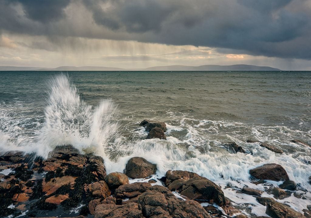
Met Éireann has issued a weather advisory for Ireland, warning of unsettled conditions over the weekend with further wet and windy weather on the way. This comes as exceptionally high supermoon spring tides could lead to coastal flooding, especially along Atlantic coasts.
The national broadcaster said, “This Friday, a brief period of heavy rain and strong winds across the country is expected.”
They are also monitoring a low-pressure system that could undergo rapid deepening on Saturday with the potential for strong winds and potentially a named storm. However, uncertainty still exists about this event.
“Additionally, we are currently in one of the highest Spring tides of the year and this, tied in with any strong winds and high waves will increase the risk of coastal flooding,” Met Éireann said.
This low-pressure system is expected to travel quickly eastwards over the Atlantic this weekend, Met Éireann’s meteorologist Liz Walsh said. “Current guidance suggests that this low will be on the southern side of the Jet Stream on Friday and will then cross over to the northern left exit region of the Jet Stream on Saturday. This system is then expected to undergo a period of rapid deepening, creating a storm depression as it swings up to the northwest of Ireland around Saturday night or Sunday morning,” it added.
Weather Advisory Explained
The Jet Stream is expected to become very active across the Atlantic later this week and into this weekend, allowing it to pick up low-pressure systems and deepen them as they cross the Atlantic. The first low-pressure system of interest is currently off the coast of Newfoundland (Canada) and this system will undergo a period of deepening as it tracks towards Iceland by Friday night. Even though the low itself won’t impact Ireland directly, an associated active frontal system will move eastwards over Ireland on Friday. All areas are likely to see a brief period of heavy rain and strong winds during the day on Friday.
The current unusually high tides, which are due to the proximity of the moon to the earth, will bring the potential for coastal flooding. Given the high astronomical tides, any strong winds and high waves will increase the risk of coastal flooding, especially along Atlantic coasts.
Storm Potential
Met Éireann meteorologists are also focusing on another area of low pressure that will be developing in the western North Atlantic, about 500 nautical miles southwest of Nova Scotia. This low-pressure system is expected to travel quickly eastwards over the Atlantic this weekend. “There is still a lot of uncertainty in the details at this time, but the potential is there for strong winds and therefore a named storm on Saturday night into Sunday,” said Liz Walsh.
Local Impacts
The Irish Meteorological Service is advising people to stay updated on the forecast through their usual channels and for live updates, check met.ie or the Met Éireann app. Local news outlets are also reporting on the potential storm and its potential impact.
Potential Storm in Tipperary
Met Éireann has issued a moderate advisory warning for Tipperary for the coming days. The advisory is valid from Thursday, October 17th, at 10 am until Saturday, October 19th, at 12 am. Met Éireann has warned that Tipperary will experience exceptionally high supermoon spring tides with coastal flooding possible. Wind warnings are also expected Saturday night and into Sunday.
Storm Potential in Mayo
Met Éireann says high spring tides will bring an ongoing risk of coastal flooding in Mayo and other parts of the country. There is a chance of coastal flooding today with heavy showers, followed by outbreaks of rain and drizzle moving in from the west tonight. It will be wet and blustery tomorrow with outbreaks of rain spreading eastwards across the country, turning heavy or thundery in places. Fresh to strong southerly winds will accompany the rain and, with very high spring tides continuing, there will be a risk of coastal flooding.
Storm Potential in Dublin
Dublin is set to brace itself as forecasters have issued a stark warning ahead of the weekend. The weather is expected to turn very stormy on Saturday night going into Sunday. Independent forecaster, Weather Alerts Ireland said, “The first storm name of the year is set to be Storm Ashley and will likely be named in the next few days. Still some uncertainty on exact path and wind speeds but the models are in agreement that this low pressure system will deepen as it pushes towards Ireland and it will move close to our shores!”
Met Éireann has warned of unsettled conditions over the weekend with further wet and windy weather on the way. Additionally, very high spring tides will bring a risk of coastal flooding over the next few days, even in the absence of heavy rain and strong winds.
Staying Safe During the Storm
It is important to stay informed about the latest weather forecasts and warnings. If you live in a coastal area, be prepared for the possibility of flooding. Secure loose objects outdoors and be careful when driving in strong winds or heavy rain. As the storm approaches, make sure you have a plan in place in case of power outages or other disruptions.
A Look Ahead
While there is still uncertainty surrounding the exact path and intensity of the storm, it is clear that Ireland is facing a period of unsettled weather. Met Éireann will continue to monitor the situation and provide updates as necessary. Stay safe and stay informed.
Stay Updated on the Storm
Here are some useful resources to stay up-to-date on the storm:
- Met Éireann: https://www.met.ie/
- Weather Alerts Ireland: https://www.facebook.com/weatheralerts.ie