Florida is bracing for what could be the United States’ heaviest-hitting hurricane so far this season, as an area of thunderstorms builds strength in the Caribbean Sea before potentially bringing life-threatening storm surge and hurricane-force winds to the Southeast later this week.
The system will pick up pace and is expected to rapidly intensify into Hurricane Helene as it approaches the coast, hurling wind, rain and storm surge further into the southeast before making an expected landfall in Florida, said the National Hurricane Center, which has dubbed it Potential Tropical Cyclone Nine.
A hurricane watch is in effect for the Gulf Coast of Florida from Englewood to Indian Pass, including Tampa Bay and Charlotte Harbor, the hurricane center said in a 5 a.m. update. A tropical storm watch is in place to the north and south of the hurricane watch area, from Indian Pass to the Walton-Bay County line and from north of Bonita Beach to Englewood.
A tropical storm watch was also issued Monday afternoon for Florida’s Dry Tortugas and part of the Keys and Monday evening for Bonita Beach to Flamingo.
Florida Gov. Ron DeSantis has declared an emergency for 41 the state’s 67 counties in an effort to expedite preparations and coordination between the state and local governments ahead of the storm’s impacts.
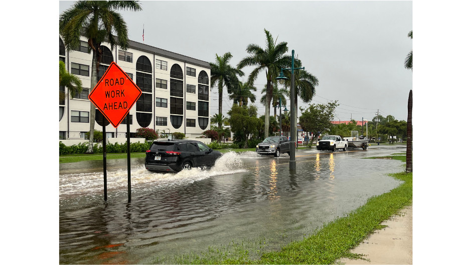
With little time to prepare, Tampa General Hospital began erecting a 10-foot-high flood barrier around the facility Monday because of the chance for storm surge and shifts in the storm’s track.
On Monday, the potential cyclone was a mass of showers and thunderstorms churning in the far western Caribbean Sea. The hurricane center predicts the system will rapidly intensify, likely becoming a hurricane by Wednesday night and eventually reaching Category 3 strength.
The last storm to make landfall in the US as a Category 3 hurricane – Idalia – also came ashore in Florida, packing winds of 125 mph and generating record-breaking storm surge from Tampa to the Big Bend in August last year.
Idalia went through a period of rapid intensification over the warm waters of the Gulf of Mexico – with its sustained winds increasing 55 mph over the course of 24 hours.
The National Hurricane Center is showing a landfall in Florida’s Big Bend region, but CNN meteorologist Mary Gilbert says anyone from Florida’s Gulf Coast to eastern Louisiana should be on alert this week.
Strong, potentially damaging winds and storm surge are likely near where the system ultimately comes ashore. The system will also churn up seas in the Gulf and could produce rough surf and dangerous rip currents for much of the basin, especially later this week.
“Strengthening is expected during the next few days, and the system is forecast to become a hurricane on Wednesday and continue strengthening on Thursday as it moves across the eastern Gulf of Mexico,” the hurricane center said in an 11 p.m. advisory Monday.
Confidence in the system’s exact track will increase after it forms, since forecast models struggle to accurately pinpoint where it could go without a center to lock onto.
This stormy weather will drop potentially flooding rainfall over portions of Central America, Mexico, Cuba and Jamaica as it tries to organize into a tropical system. Hurricane and tropical storm watches are already in effect for parts of Mexico and Cuba.
“Potential Tropical Cyclone Nine will bring heavy rain to portions of the western Caribbean, which will cause considerable flooding and mudslides across western Cuba,” the National Hurricane Center said.
In its Monday 5 p.m. ET forecast discussion the hurricane center warned that the system’s expansion over the record-warm Gulf of Mexico would have far-reaching impacts for the US.
The “storm surge, wind, and rainfall impacts will extend well away from the center, particularly to the east of the system. In addition, the fast forward speed as it approaches the coast will likely result in farther inland penetration of gusty winds over parts of the southeastern United States after landfall,” it said.
Heavy rainfall is possible for much of the Southeast starting around midweek. A level 2 of 4 risk of flooding rain is in place for much of Florida, Georgia, Alabama and parts of the Carolinas Thursday, according to the Weather Prediction Center.
Helene could also bring strong winds and torrential rainfall to much of Georgia and the Carolinas by Friday. This could lead to dangerous flooding and significant power outages.
“Heavy rainfall will likely result in locally considerable flash and urban flooding across portions of Florida, with isolated flash and urban flooding possible across the Southeast, Southern Appalachians, and the Tennessee Valley Wednesday through Friday. Minor to isolated moderate river flooding will be possible,” the National Hurricane Center said.
Helene would be the fourth hurricane to make landfall in the US this year and the fifth hurricane to slam Florida since 2022.
The repeated blows have pushed Florida’s insurance market to the brink, with insurers pulling out of the state because of the increasing risk of extreme weather due to climate change.
Potential Tropical Cyclone Nine Is Expected to Become a Hurricane This Week
Potential Tropical Cyclone Nine is expected to organize and be a hurricane threat to the U.S. Gulf Coast later this week.
You can track the storm with the maps below. For the full forecast details, please read our latest article here.
Preparations Underway in Florida
SARASOTA, Fla. (WWSB) - In advance of Potential Tropical Cyclone Nine, Gov. Ron DeSantis has declared a state of emergency for 41 Florida counties.
“There is a significant threat of storm surge, coastal flooding and erosion, heavy rainfall and flash flooding, and damaging winds to the Florida Gulf Coast,” reads the order.
Areas in Sarasota County and Manatee County are still recovering from the heavy rains and flood waters of Debby.
The counties listed in the emergency declaration include: Alachua, Bay, Bradford, Calhoun, Charlotte, Citrus, Collier, Columbia, Dixie, Escambia, Franklin, Gadsden, Gilchrist, Gulf, Hamilton, Hernando, Hillsborough, Holmes, Jackson, Jefferson, Lafayette, Lee, Leon, Levy, Liberty, Madison, Manatee, Marion, Monroe, Okaloosa, Pasco, Pinellas, Santa Rosa, Sarasota, Sumter, Suwannee, Taylor, Union, Wakulla, Walton, and Washington counties.
Hurricane Helene: A Major Threat for the Gulf Coast
The National Hurricane Center said Monday afternoon that a major hurricane will make landfall along the Florida Gulf coast on Thursday. The storm, which is still taking shape and will be named Helene, could become the strongest hurricane to hit the United States this season.
Forecast to rapidly intensify and come ashore as a Category 3 storm with sustained winds exceeding 111 miles per hour, Helene poses a significant threat to Florida residents.
“While it is too soon to pinpoint the exact location and magnitude of impacts, the potential for life-threatening storm surge and damaging hurricane-force winds along the coast of the Florida Panhandle and the Florida west coast is increasing,” the National Hurricane Center said in its 5 p.m. ET bulletin.
Florida Gov. Ron DeSantis declared a state of emergency earlier in the day in 41 counties. Helene is expected to make landfall near the Big Bend region of the Florida panhandle but could shift course over the coming days.
In addition to high winds, the storm will threaten millions of residents along the Gulf Coast with up to 12 inches of rainfall, as well as the possibility of tornadoes.
“In the past, major hurricanes, containing maximum sustained wind speeds of at least 111 mph, have developed in similar setups,” said AccuWeather meteorologist Alex Duffus.
According to a 5 p.m. ET advisory, the storm is about 315 miles southeast of the western tip of Cuba with maximum sustained winds of 35 mph, while moving north-northwest at 7 mph.
However, over the next day or two, meteorologists predict, that the system will turn into a tropical depression or storm as it moves northwest on Tuesday.
“The Tampa Bay region is extremely vulnerable to storm surge. If this storm tracks any farther west, we could end up dealing with a serious storm surge and flooding problems in Tampa,” AccuWeather lead hurricane expert Alex DaSilva predicted.
But meteorologists warned residents from Louisiana to Key West, Fla., to prepare for the storm.
The National Hurricane Center issued hurricane watches and tropical storm warnings on Monday for parts of Mexico and Cuba as the storm intensifies over the record-warm Gulf of Mexico.
The storm is expected to weaken by Friday as it moves inland across the Southeast. However, heavy rainfall and wind gusts will linger along its path.
Preparations Across the Southeast
Florida, which was pummeled by Hurricane Debby earlier this season, is bracing for another storm this week. In Leon County, home to Tallahassee, 15 sandbags will be available for each household to take home to prepare against heavy rain and flooding.
With the forecast still uncertain, DeSantis has already declared a state of emergency in 41 counties. The declaration allows the state to execute its Comprehensive Emergency Management plan, allowing the use of resources for any logistical, rescue or evacuation operations.
“Now is the time to make an emergency plan, know your evacuation zone, and be as prepared as possible for the storm,” DeSantis said in a post on X.
As of 5 p.m. ET on Monday, the NHC advisory posted a hurricane watch in effect for:
- Cabo Catoche, Quintana Roo, Mexico, to Tulum, Mexico
- Pinar del Río Province, Cuba
A tropical storm warning was in effect for:
- Rio Lagartos, Mexico, to Tulum, Mexico
- Artemisa Province, Cuba
- Pinar del Río Province, Cuba
- Isle of Youth, Cuba
A tropical storm watch was in effect for:
- Dry Tortugas, Monroe County, Fla.
- Lower Keys, Fla., south of the Seven Mile Bridge, Monroe County, Fla.
Potential Tropical Cyclone Nine: Tracking and Potential Impacts for Tampa Bay
TAMPA, FL — A tropical storm will probably develop by Tuesday in the Western Caribbean, then it will likely strengthen into a hurricane by Wednesday.
As of early Tuesday, a Hurricane Watch has been issued for the Gulf Coast of Florida from Englewood northward and westward to Indian Pass, including Tampa Bay.
A Flood Watch has been issued for our area from Wednesday evening through Friday morning. 3 to 6 inches of rain, potentially higher amounts depending on the future track.
Several Central Florida counties are also under a Tropical Storm Watch ahead of the expected major hurricane developing this week. Those counties include Sumter, Lake, Orange, Seminole, and Osceola.
Potential Tropical Cyclone Nine is expected to be Tropical Storm Helene today in the NW Caribbean then strengthen into a hurricane and be a major hurricane in the eastern Gulf of Mexico by Thursday.
An area of high pressure is expected to move east while a trough drops into the central U.S. This steering pattern will cause “Helene” to move N-NNE over the eastern Gulf of Mexico.
In terms of intensity, this storm is expected to become a major category 3 hurricane.
While it’s too soon to pinpoint an exact landfall location, there is a threat of a significant storm surge and damaging winds for our area.
The closer the eye is to our coast, the worse the impacts will be. Even if the storm stays far off to the west, we expect to get heavy rain, strong wind squalls, possible tornadoes, and the threat of storm surge.
Power outages are likely.
With such a range of possible landfall locations, this could lead to a number of different outcomes for the Tampa Bay region.
No matter the outcome, the timing of impacts for the Tampa Bay area look to start late Wednesday night and end Thursday night.
The reason for such high uncertainty lies in its lack of development.
While it has been designated as Potential Tropical Cyclone 9, it still does not have an organized center.
It is much more difficult to forecast a storm that hasn't developed, than one that has.
The models are just guessing where an approximate center of the storm is now and going from there.
If the model is wrong about where the center is now, it most certainly will be wrong about where it will be on Thursday.
However, we can still outline possible scenarios that could pan out on Thursday.
A best-case scenario for the Tampa Bay and Nature Coast regions will be a track up the western side of the current forecast cone.
The area will still see bands of heavy rain starting Wednesday, then becoming more consistent on Thursday near the coast.
In this scenario, landfall would be in the Panhandle, around Apalachicola or west, with the center passing over 100 miles west of Tampa Bay.
Some coastal flooding would occur, but it would be minor, and only in the most flood-prone areas.
Wind gusts to 40 mph would be possible near the coast and power outages would be isolated.
The main impacts in the scenario would be minor coastal flooding and nuisance wind gusts.
Inland flooding would not be a huge concern, and rainfall amounts would be around 1 to 3 inches.
The worst-case scenario for the area would certainly be a track up the eastern side of the current forecast cone.
This would mean a landfall just to the north of Tampa Bay.
While this is not a likely scenario, it is within the realm of possibility.
The biggest impact would be storm surge in this case.
While it would be hard to put an exact value to it at this point, it certainly would be a higher surge than anything seen in the area in many decades.
Hurricane-force winds would be likely in this scenario with many power outages along with damage to property.
Rainfall would still be on the low end for a hurricane, as it would be a fast moving storm.
Rainfall totals would be around 3 to 6 inches.
A solution somewhere in the middle appears the most likely for now.
This would mean a landfall in the Big Bend region.
While we certainly would not get the brunt of the impacts around Tampa Bay, we would still get some sizable ones.
A scenario like this could be similar to what transpired with Idalia last year.
Several feet of storm surge would be possible around the Tampa Bay area with the biggest surge impacts in our region on the Nature Coast.
In this scenario, hurricane-force winds would likely stay just west of us, but gusts over 50 mph would still be possible.
Scattered power outages would be possible, along with some minor wind damage to property.
Rainfall would be around 2 to 4 inches, so the inland flood risk would be low.
Stay updated as the track will become more certain during the day on Tuesday and impacts will become more clear.
For now, these are just possible scenarios, not definitive ones.
Preparations in South Georgia
ALBANY, Ga. (WALB) - A First Alert Weather Day has been issued for Thursday, Sept. 26 as severe weather is expected from a possible major hurricane.
Tropical storm conditions are likely for parts, or all, of South Georgia. Hurricane conditions are possible, especially for the southern communities.
Monday’s NHC forecast track projects the disturbance in the western Caribbean Potential Tropical Cyclone Nine will become a tropical storm tonight or early Tuesday then a category one hurricane in the Gulf on Wednesday then a stronger category 2 Wednesday night. By Thursday afternoon potentially a major category 3 hurricane with 115mph winds.
On the latest track landfall, Thursday pm/evening along the NE Gulf coast then tracking inland into SGA. The storm tracks north quickly with continuous heavy rain, potential flash flooding, damaging winds (downed trees, powerlines and power outages and possible tornadoes.
Expect a few showers Wednesday afternoon then the outer bands of heavy rain and winds pick up overnight into Thursday and continue into Friday. Definitely a long duration of deteriorating conditions.
These conditions are expected to move in early Thursday and continue through the afternoon and evening into Friday.
Generally, four to six inches of rain is expected, potentially leading to areas of flash flooding.
The following counties are currently under flood watch:
Expect threats of strong winds with gusts of up to 75 miles per hour which may lead to downed trees, and powerlines resulting in possible power outages.
There is also a threat of isolated tornadoes.
Although the probability of destructive impacts on the storm’s path into SGA has increased, changes are expected.
Always be weather ready with these resources:
Have a news tip or see an error that needs correction? Let us know. Please include the article’s headline in your message.
To stay up to date on all the latest news as it develops, follow WALB on Facebook and X (Twitter). For more South Georgia news, download the WALB News app from the Apple Store or Google Play.
Conclusion: Stay Informed and Be Prepared
As Hurricane Helene approaches, it’s crucial to stay informed about the latest forecasts and warnings. Be prepared with an emergency plan, including having a supply of food, water, and essential supplies. Stay vigilant and be ready to take action as necessary.