A massive landslide in a Greenland fjord triggered a wave that “shook the Earth” for nine days. The seismic signal last September was picked up by sensors all over the world, leading scientists to investigate where it had come from.
The results of the investigation into this event, which are published in the journal Science, are the result of a detective mission involving an international team of scientists and the Danish Navy. “When colleagues first spotted this signal last year, it looked nothing like an earthquake. We called it an ‘unidentified seismic object’,” recalled Dr Stephen Hicks from UCL, one of the scientists involved. “It kept appearing - every 90 seconds for nine days.”
A group of curious scientists started to discuss the baffling signal on an online chat platform. “At the same time, colleagues from Denmark, who do a lot of fieldwork in Greenland, received reports of a tsunami that happened in a remote fjord,” explained Dr Hicks. “So then we joined forces.”
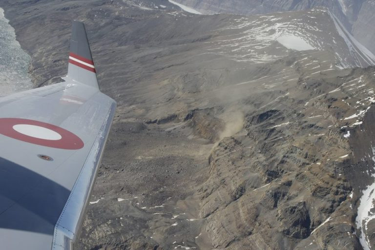
The team used the seismic data to pin down the location of the signal’s source to Dickson Fjord in East Greenland. They then gathered other clues, including satellite imagery and photographs of the fjord that were taken by the Danish Navy just before the signal appeared.
A satellite image showed a cloud of dust in a gully in the fjord. Comparing photographs before and after the event revealed that a mountain had collapsed and swept part of a glacier into the water.
The researchers eventually worked out that 25 million cubic metres of rock - a volume equivalent of 25 Empire State Buildings - slammed into the water, causing a 200m-high “mega-tsunami”. In the “after” photographs of the location, a mark is visible on the glacier - left by the sediment that the giant wave hurled upwards.
The landslide - a mountainside of rock that collapsed and carried glacial ice with it - triggered a 200m wave. That wave was then “trapped” in the narrow fjord - moving back and forth for nine days, generating the vibrations.
Tsunamis, usually caused by underground earthquakes, dissipate within hours in the open ocean. But this wave was trapped. “This landslide happened about 200km inland from the open ocean,” Dr Hicks explained. “And these fjord systems are really complex, so the wave couldn't dissipate its energy.”
The team created a model that showed how, instead of dissipating, it sloshed back and forth for nine days. “We’ve never seen such a large scale movement of water over such a long period,” said Dr Hicks.
Scientists say the landslide was caused by rising temperatures in Greenland, which have melted the glacier at the base of the mountain. “That glacier was supporting this mountain, and it got so thin that it just stopped holding it up,” said Dr Hicks. “It shows how climate change is now impacting these areas.”
While this event was in a a remote area, these fjords are visited by some Arctic cruise ships. Fortunately none were in the area where this landslide occurred. But the lead researcher, Dr Kristian Svennevig from the National Geological Surveys for Denmark and Greenland (GEUS), said this was an increasingly common phenomenon in the Arctic.
“We are witnessing a rise in giant, tsunami-causing landslides, particularly in Greenland,” he told BBC News. “While the Dickson Fjord event alone doesn't confirm this trend, its unprecedented scale underscores the need to carry out more research.”
The event at Dickson Fjord, Dr Hicks added, “is the perhaps first time a climate change event has impacted the crust beneath our feet all the world over.”
The collapse of a 1,200-metre-high mountain peak into the remote Dickson fjord happened on 16 September 2023 after the melting glacier below was no longer able to hold up the rock face. It triggered an initial wave 200 metres high and the subsequent sloshing of water back and forth in the twisty fjord sent seismic waves through the planet for more than a week. Landslides like this, scientists say, are happening more frequently with climate change - as the glaciers that support Greenland's mountains melt.
The landslide and mega-tsunami were the first recorded in eastern Greenland. Arctic regions are being affected by the most rapid global heating, and similar though seismically smaller events have been seen in western Greenland, Alaska, Canada, Norway and Chile.
Dr Kristian Svennevig from the Geological Survey of Denmark and Greenland, the lead author of the report, said: “When we set out on this scientific adventure, everybody was puzzled and no one had the faintest idea what caused this signal. It was far longer and simpler than earthquake signals, which usually last minutes or hours, and was labelled as a USO – an unidentified seismic object.
“It was also an extraordinary event because it is the first giant landslide and tsunami we have recorded in east Greenland at all. It definitely shows east Greenland is coming online when it comes to landslides. The waves destroyed an uninhabited Inuit site at sea level that was at least 200 years old, indicating nothing like this had happened for at least two centuries.
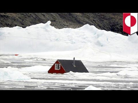
A large number of huts were destroyed at a research station on Ella Island, 70km (45 miles) from the landslide. The site was founded by fur hunters and explorers two centuries ago and is used by scientists and the Danish military, but was empty at the time of the tsunami.
The fjord is also on a route commonly used by tourist cruise ships and one carrying 200 people was stranded in mud in Alpefjord, close to Dickson fjord, last September. It was freed just two days before the tsunami struck, avoiding waves estimated at four to six metres.
“It was pure luck that nothing happened to any people here,” said Svennevig. “We are in uncharted waters scientifically, because we don’t really know what a tsunami does to a cruise ship.”
Dr Stephen Hicks at University College London, one of the research team leaders, said: “When I first saw the seismic signal, I was completely baffled. Never before has such a long-lasting, globally travelling seismic wave, containing only a single frequency of oscillation, been recorded.”
The signal looked completely different to multi-frequency rumbles and pings from earthquakes. It took 68 scientists from 40 institutions in 15 countries to solve the mystery by combining seismic data, field measurements, on-the-ground and satellite imagery, and high-resolution computer simulations of tsunami waves.
The analysis, published in the journal Science, estimated that 25m cubic metres of rock and ice crashed into the fjord and travelled at least 2,200 metres along it. The direction of the landslide, at 90 degrees to the length of the fjord, along with the inlet’s steep parallel walls and a 90-degree bend 10km down the line all helped to keep much of the landslide’s energy within the fjord and resonating for so long.
The tsunami wave reduced to seven metres within a few minutes, the researchers calculated, and would have fallen to a few centimetres in the days after, when the Danish military visited and photographed the fjord. But this sloshing of a vast body of water continued to send seismic waves across the world.
Coincidentally, sensors measuring water depth had been set up by scientists in the fjord two weeks before the landslide. “That was also pure luck,” said Svennevig. “They were sailing below this glacier and mountain that they didn’t know was about to collapse.”
A key part of determining the cause of the seismic event was modelling the tsunami and comparing it against the measurements. “Our model predicted an oscillation with exactly the same period – 90 seconds – which is an amazing result, as well as the height of the tsunami, and the waves decayed in exactly the same way as seismic signals. That was the eureka moment.”
Prof Anne Mangeney, a landslide modeller at the Institut de Physique du Globe de Paris in France, who was part of the team, said: “This unique long-duration tsunami challenged the classical models that we previously used to simulate just a few hours of tsunami propagation – we had to go to an unprecedentedly high numerical resolution. This opens up new avenues for tsunami modelling.”
Such events will become more common as global temperatures continue to rise. “Even more profoundly, for the first time, we can quite clearly see this event, triggered by climate change, caused a global vibration beneath all of our feet, everywhere around the world,” said Mangeney. “Those vibrations travelled from Greenland to Antarctica in less than an hour. So we’ve seen an impact from climate change impacting the entire world within just an hour.”
Humans’ impact on the planet was also demonstrated recently by studies showing that the reshaping of the Earth by the mass melting of polar ice was making the length of each day longer and causing the north and south poles to shift. Other work has shown that carbon emissions are shrinking the stratosphere.


