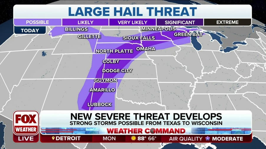
Midwest Faces Threat of Powerful Storms: Damaging Winds and Hail Expected
A wide swath of the country is facing a chance of potentially dangerous thunderstorms as the work week gets underway. Storms will roll across the Plains states and into the Midwest, some with potentially damaging winds and hail, meteorologists predicted Sunday.
The heat dome that has baked the western United States is expected to shift, meaning hotter temperatures in the southern and central Plains states. That shift will fuel the thunderstorms, forecasters said, which could persist well into the week and stretch into the first part of August.
A Similar Pattern to July 15th
"The weather pattern this week is expected to feature similar characteristics to what was observed back on July 15 across the Midwest, which ultimately ended up producing a powerful derecho across Iowa and northern Illinois," AccuWeather Senior Meteorologist Adam Douty said.
The hot and humid air allows the severe weather fronts to "reload" and continue to bring strong storms to the region, which are typical for this time of year, but which can create damaging, rogue storms within a matter of just a few hours or less.
Potential for Strong Winds and Flash Floods
Meteorologists say the conditions could exist for storms that will produce winds of up to 95 miles per hour. People in a stretch from the Dakotas to Wisconsin to Illinois should be prepared for dangerous and powerful storms, they said. People should also be on the lookout for flash floods.
Impacts on Agriculture
The threat of severe weather comes as farmers across the Midwest are preparing for harvest. The storms could damage crops and delay harvesting efforts. The National Weather Service is urging farmers to monitor weather forecasts closely and take steps to protect their crops.
Other Weather Updates
While showers and thunderstorms are set to continue across the South and Southeast, frequency and coverage will be on the downtrend. Meanwhile, extreme heat grapples the northern High Plains as smoke expands across the nation.
Looking Ahead: A Break from the Soggy Pattern
As we head into the weekend, this soggy pattern across the South and Southeast U.S. will finally begin to break down as high pressure builds in. However, with the rain and clouds clearing out, expect temperatures to be on the rise.
Persistent Heatwave in the Northern High Plains
The heatwave sweeping across the northern High Plains will continue its eastward march. Although widespread temperature records aren't expected today as they were earlier this week, temperatures will remain dangerously high. Many areas from the Dakotas to Oklahoma could see afternoon highs reaching over 100°F.
Smoke Impacts Spread Across the Country
Nearly 100 wildfires are burning across the U.S. West Coast and southwest Canada, with the most severe in Oregon and Washington. The fires are causing extensive smoke and haze, worsening air quality in the region. Strong westerly winds carry the smoke to the East Coast, affecting air quality in cities across Delaware, New Jersey, Cape Cod, New Hampshire, New York City, and parts of Maine.
Tropical Activity in the Pacific
Tropical Storm Bud is active in the Eastern Pacific, moving westward with 20-25 knots winds, and is not expected to threaten land. In the next seven days, no other tropical activity is expected in the Eastern Pacific or Atlantic Oceans.
App Update: New Home Location Feature
We've made a few changes to the Weather & Radar app on Android. When you delete your old home location, your current location becomes your new home location. This update is available with version 2024.15.1.
Storms Continue to Threaten Agriculture
The severe weather threat is a significant concern for farmers in the Midwest, as the region is in the midst of the harvest season. The potential for damaging winds, hail, and flooding could lead to crop damage and delays in harvesting operations. Many farmers have been working tirelessly to get their crops in before the storms hit, but the threat of severe weather remains a major challenge.
The Importance of Monitoring Weather Forecasts
As the severe weather threat continues, it is crucial for everyone in the affected areas to stay informed and prepared. The National Weather Service is urging residents to monitor weather forecasts closely and take necessary precautions. This includes having a plan in place for severe weather, such as a safe place to go in case of a tornado warning, and having an emergency kit ready.
The Importance of Preparedness
Staying informed and prepared is crucial during severe weather events. Farmers need to be aware of the potential for damage to crops and take necessary steps to protect their investments. Residents in the affected areas should be aware of potential hazards such as damaging winds, hail, and flooding, and be prepared to take shelter if needed. By taking steps to stay informed and prepared, we can minimize the impact of severe weather and protect ourselves and our communities.