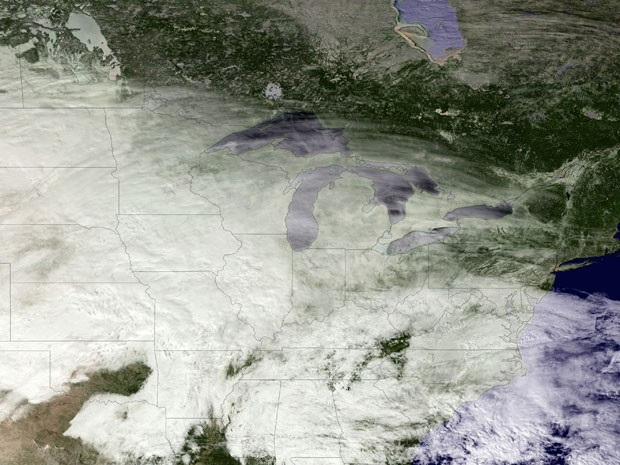
Southern Ontario Snowstorm: Up to 40 Centimeters Expected
Residents in parts of southern Ontario are bracing for a significant winter storm, with Environment Canada issuing snow squall warnings for several regions. The storm, fueled by lake-effect snow from Lake Huron and Georgian Bay, is expected to drop substantial amounts of snow, causing hazardous travel conditions and potential disruptions. Commuters cross Front St. at Bay St. near Union Station, a scene that will soon be drastically altered by the incoming snowfall.
Areas Affected by Snow Squall Warnings
A number of snow squall warnings were in effect Saturday, many active since Thursday. The warnings currently cover a wide swathe of Southern Ontario, including but not limited to Barrie, Orillia, and northern Durham and York regions, which are expected to receive an additional 20 to 40 centimetres of snow by Sunday. The Sault Ste. Marie area is also under a snow squall warning, with Environment Canada predicting up to 30 centimetres of accumulation by Sunday. Kitchener, Cambridge and the Region of Waterloo, having already received over 15 centimetres of lake-effect snow off Lake Huron, were added to the snow squall watch list earlier on Saturday. Newmarket, Georgina, northern York Region, Barrie, Collingwood, Hillsdale, Uxbridge, Beaverton, and northern Durham Region are also included in the warnings.
Impact of the Snow Squalls
Environment Canada warns that heavy and blowing snow can significantly reduce visibility, potentially creating dangerous driving conditions. The agency strongly urges those travelling in the affected areas to postpone non-essential travel until conditions improve. Police responded to multiple collisions across southern Ontario on Saturday, further emphasizing the hazardous conditions brought on by the heavy snowfall. In posts on social media, the Ontario Provincial Police highlighted several reports of collisions and urged drivers to avoid traveling if possible. Although no serious injuries have been reported from the collisions thus far, the situation emphasizes the significant risks associated with driving in these conditions. The intensity of the snow squalls is expected to diminish on Sunday, but travel conditions will remain challenging.
Toronto's Weather Forecast
While areas north of Toronto are preparing for a substantial snowfall (potentially up to 40 centimeters), Toronto itself is expected to receive only about two centimetres of snow. However, the city will still experience strong winds moving west at 30 km/h and gusting to 50 km/h, with a wind chill making temperatures feel closer to -13°C. The city opened its warming centers on Friday in anticipation of these dropping temperatures, which fell to -4°C overnight according to data recorded at Toronto Pearson International Airport. The chilly weather is expected to continue into Sunday, with flurries forecast to end that afternoon after winds reach speeds of up to 40 km/h in the morning.
Preparing for the Storm
Environment Canada stresses that snow squalls cause weather conditions to vary considerably, and changes from clear skies to heavy snow within a few kilometres are common. They advise motorists to slow down, look out for tail lights ahead, and be prepared to stop if visibility is reduced. The weather agency's warning emphasizes the need to prepare for quickly changing and deteriorating travel conditions. A weather advisory is also in effect for areas east of the GTA, like Peterborough, Pickering, and Oshawa, where snowfall of five to 10 centimeters is expected as the lake-effect snow blows inland. The potential for significant snowfall accumulation, coupled with high winds and reduced visibility, underscores the importance of taking necessary precautions and prioritizing safety during this period of severe weather.
Staying Safe During the Storm
Beyond postponing non-essential travel, residents in affected areas should take several precautions to stay safe. These include ensuring vehicles are properly winterized with clear visibility and keeping a full tank of gas; having an emergency kit in your vehicle, including blankets, extra warm clothing, a shovel, food, and water; and staying informed about weather updates and warnings from Environment Canada. Additionally, checking on elderly neighbours and those who may be vulnerable during extreme weather conditions can be a valuable community support measure. The snowfall is significant, the conditions will be difficult, and preparation is key to mitigating the potential impacts of this event.
Looking Ahead: A Winter Wonderland, or a Winter Nightmare?
The impact of this storm will vary across the region. While some areas will see an accumulation of up to 40 centimetres of snow, others will experience more moderate snowfall. However, the widespread snow squall warnings and potential for rapidly changing conditions emphasize the importance of preparedness for all residents of southern Ontario this weekend. The outcome, whether it becomes a beautiful winter wonderland or a severe weather nightmare, depends on several factors, including the duration and intensity of the lake-effect snow and the responsiveness of local authorities. With preparations made and safety prioritised, we can navigate this weather event with greater ease.


