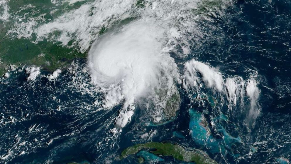
Tropical Storm Debby, which has already dumped more than a foot of rain on parts of the South and is forecast to bring more, made a second landfall in the U.S. early Thursday when it crossed back into South Carolina. The storm, which had 50 mph winds, made landfall near Bulls Bay, South Carolina, the National Hurricane Center said in a 2 a.m. ET update. It was a Category 1 hurricane when it first made landfall near Steinhatchee in Florida’s Big Bend region at 7 a.m. Monday.
The death toll from Tropical Storm Debby is rising after its second US landfall early Thursday. At least six people have now died because of the storm after it spawned a destructive tornado Thursday that killed a man in Lucama, North Carolina. The tornado damaged homes and a school in the area, which is around 35 miles southeast of Raleigh.
Since crashing into Florida as a Category 1 hurricane on Monday, Debby has dumped more than a foot of rain over parts of Florida, Georgia, South Carolina and North Carolina. The deluges have engorged rivers, flooded roadways and trapped people in cars, homes and boats – and potentially dangerous heat is expected across the region in the coming days, threatening to complicate the recovery process.
Debby’s Death Toll Climbs
One person is dead after a tornado spawned by Debby tore through part of North Carolina’s Wilson County in the earliest hours of Thursday morning, leaving behind damage to a middle school, a church and multiple homes. A man was killed after his home in the town of Lucama collapsed, a county spokesperson told CNN. At least four people in Florida and one in Georgia were also killed by Debby.
Debby’s Current Path
The system will pick up additional speed and lose more strength Thursday as it moves through North Carolina and into northern Virginia by Friday morning. Debby will accelerate through Pennsylvania and New York Friday and move through New England by early Saturday afternoon, bringing heavy rain and flash flooding to a region drenched by storms earlier this week.
Debby’s Impacts Across the Southeast
Debby’s deluge has been a clear illustration of the impact of global warming caused by fossil fuel pollution, which is causing storms to get wetter and strengthen more quickly. Debby, for instance, tracked through near-record warm waters in the Gulf of Mexico, which helped it rapidly intensify before making landfall as a hurricane in Florida. As Debby has churned through the Southeast, the storm has left behind disastrous scenes. Homes have been shredded by winds and swamped by floodwaters, and roads have been washed out or submerged, creating hazardous conditions for impacted communities.
A Backyard Paradise for Alligators
In South Carolina’s Lowcountry, a home in Bluffton has become an alligator’s paradise as floodwaters turned Adrienne LeBlanc’s yard into an inviting swampland. Though LeBlanc is no stranger to alligators – often seeing them sunbathing in the distance – she was surprised to wake up after heavy rains Wednesday to discover her backyard had been invaded by alligators. “It’s like National Geographic in our backyard right now,” LeBlanc told CNN. She counted eight alligators swimming around her house and saw a few of them wrestling. After 17 years of living in Bluffton, LeBlanc said she has experienced this level of flooding once – when Hurricane Matthew made landfall in the state in 2016.
FEMA Responds to the Storm
As Tropical Storm Debby continues its path northeast, FEMA advises residents in North Carolina, South Carolina and Virginia to stay informed and take necessary precautions to ensure their safety as heavy rainfall, strong winds and potential flooding are expected in the coming days. For those living further north, the time to prepare is now. FEMA is working closely with federal, state, tribal and local officials, coordinating efforts and resources to respond effectively to the challenges posed by this severe weather event. More than 900 FEMA staff and federal partners are deployed in Florida, Georgia, North Carolina and South Carolina. Search and Rescue Teams and swift water rescue assets stand ready to assist as needed. Additionally, FEMA’s National Response Coordination Center in Washington, D.C. and its Regional Response Coordination Centers remain active, monitoring the storm’s path, supporting the affected states and anticipating any needs they may have.
North Carolina Braces for Continued Impact
Tropical Storm Debby continues to bring heavy rain and flooding across North Carolina on Thursday. The storm also brought its first fatality following a tornado late Wednesday night in Lucama. On Thursday morning, Governor Roy Cooper visited the North Carolina Emergency Management Regional Coordination Center East and the North Carolina National Guard Armory in Kinston, NC, along with North Carolina Emergency Management Director Will Ray and FEMA Federal Coordinating Officer Rod McAllister.
“Tropical Storm Debby continues to bring dangerous rain and flooding to many areas of our state,” said Gov. Cooper. “I’m grateful for the work of first responders and urge people to take precautions against this storm and listen to guidance from state and local Emergency Management officials.”
The Governor and Director Ray met with members of the State Emergency Response Team and received a briefing on the current situation and response efforts by the state and regional officials. The North Carolina Emergency Management Regional Coordination Centers continue to provide support to local response partners to respond to impacts of Tropical Storm Debby. At the North Carolina National Guard Armory in Kinston, Governor Cooper and Director Ray met with soldiers and airmen deployed to support the state’s response and swift water rescue teams positioned for response to eastern North Carolina areas needing assistance.
Navigating the Aftermath: Tips for Safety and Recovery
Homeowners and renters whose properties have been damaged by the storm should contact their insurance providers immediately. For those with flood insurance through the National Flood Insurance Program (NFIP), FEMA has established hotlines to expedite claims processing and provide guidance on next steps. For more information about flood insurance claims, visit www.floodsmart.gov or call the NFIP Helpline at 1-800-427-4661. Stay safe and be aware of flood risks. Do not walk, swim or drive through flood water as it may be contaminated and contain dangerous debris. Additionally, underground or downed power lines can electrically charge the water. Turn Around, Don’t Drown! Remember, just six inches of moving water can knock you down and one foot of moving water can sweep your vehicle away. Stay off bridges over fast-moving water and never drive around barricades. Local responders use them to safely direct traffic out of flooded areas.
Be ready to evacuate. Excessive rainfall may cause waters to rise rapidly, so you may need to evacuate with little notice. Residents and visitors should pay attention to local officials and heed any guidance, warnings or instructions as risk of flooding continues over the coming days. To find an open shelter, you can text the word SHELTER and your zip code to 43362 to search for shelters near you and for Spanish speakers, text REFUGIO and your zip code to 43362.
Looking Ahead
South Carolina hasn’t seen a named storm make landfall on its shores since Hurricane Ian’s arrival in 2022 as a Category 1 storm. The last named storm to track across the state in any fashion was Tropical Storm Idalia in August 2023. This is a developing story and will be updated.


