A tropical storm is expected to form in the northwest Caribbean Sea and may become a hurricane before it heads toward either Florida or the northern Gulf Coast late this week. Interests along the U.S. Gulf Coast from Louisiana to Florida should monitor this situation closely and stay updated on how the forecast unfolds in the days ahead.
The area to watch: A broad area of low pressure has formed over the western Caribbean Sea. Thunderstorms are already becoming more numerous in this area. It's been dubbed "Invest 97L", a convention used by the National Hurricane Center to identify features they are monitoring for future development. The NHC also scheduled its first Hurricane Hunter mission to the western Caribbean Sea for Monday afternoon.
Here is when a storm could form and where it could track:
-
Monday-Tuesday: The latest computer forecast models suggest a tropical depression or storm could form as soon as late Monday or Tuesday. By Tuesday, it could near Cancún and Cozumel or western Cuba. Locally heavy rain is possible in those areas. The next storm name is Helene.
-
Wednesday: We expect this system to enter the southern Gulf of Mexico, as a tropical storm or hurricane.
-
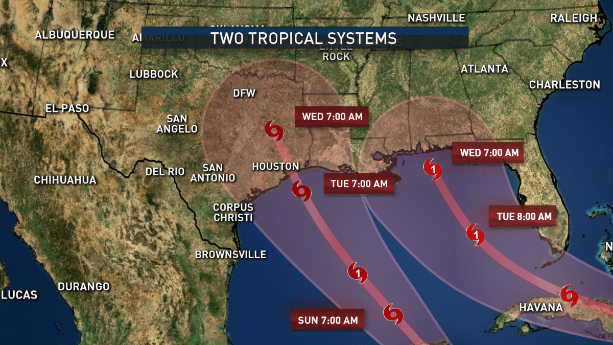
Thursday: We expect the system to be drawn northward in the Gulf of Mexico by steering winds around high pressure off the Southeast coast and low pressure over the south-central U.S. As usual, forecast models differ somewhat this far out. But in general, that could bring the center of this system to the Gulf Coast somewhere between Florida and Louisiana either Thursday or Thursday night, possibly as a hurricane.
-
Friday: This system is most likely to continue inland with weakening winds, but locally heavy rain over the Southeast.
How strong could it become: It's increasingly possible this system could become a hurricane in the Gulf. That's because heat content is one favorable ingredient for intensification, and the map below shows there is plenty of deep, warm water in the northwest Caribbean and parts of the Gulf of Mexico. But there are other factors that also matter, like the upper-level wind pattern. These upper level winds could spread apart over the system, which is favorable for strengthening, or they could blow over the top of the system, which might favor holding the system's intensity steady or weaken it a bit.
Interests along the U.S. Gulf Coast, particularly in Florida, should monitor the situation closely while also making sure hurricane preparedness plans are in place. Check back with us at weather.com and The Weather Channel app for updates through the weekend and beyond as we fill in more details on what to expect.
Rainfall potential: While it's far too soon for specifics on other impacts - including storm surge and winds - we expect this future storm to produce heavy rainfall generally along and to the east of its track. The heaviest rain is expected Thursday into Friday in parts of the Southeast, but some bands of heavy rain could arrive as early as Wednesday. This rain could lead to flash flooding, especially where it combines with storm surge and over higher terrain.
The timing of the system’s development, and the movement that positions the storm in the Gulf of Mexico, will have an important impact on how it tracks towards the United States late-week. Residents from coastal Louisiana to the west coast of Florida are encouraged to monitor the forecast for the next several days. While it is too soon to pinpoint where the system will ultimately go, the Florida panhandle, through the Big Bend area, could be focal point for impact later in the week.
However, exactly where the system tracks will not be the only focus. The size and the intensity of a storm can present far-reaching impacts, away from the storm’s center. This could include locally heavy rainfall, isolated severe storms and a dangerous rip current risk for both sides of the Florida peninsula. For South Florida, our weather will be determined by the anticipated storm’s position and intensity. This could include breezy conditions, passing downpours, high surf and dangerous marine conditions.
Invest 97-L is identified in the Western Caribbean and is forecast to track into the Southern Gulf of Mexico by midweek. Gradual development of this system is expected, and a tropical depression is likely to form. The National Hurricane Center is giving this system a 40% chance of development over the next 2 days, and an 80% chance over the next 7 days. Our forecast set up for what will be steering the tropical system, is an unusual one. A storm system will get pinched off from the steering winds of the jet stream, and will be "cut off" allowing itself to spin around and meander wherever it likes over the South Central U.S. by midweek. Forecasts are in excellent agreement for these storm to merge once the tropical system moves on shore. Any change in placement of the "cut off low" will have a big influence on where the tropical system will track before making landfall. Since cut off lows are notorious for being unreliably forecast, I have low confidence in the exact track of the tropical system at this time. Deterministic forecast data are still in pretty good agreement in taking the storm well east of New Orlans and Southeast Louisiana and making landfall somewhere around Thursday evening. The best forecasts from here in the U.S. are the farther west right now. Forecasts out of Europe are a bit more east. Forecast data out of Canada, Germany, and Japan are more in line with the European forecast.
Invest 97L is likely to become a tropical depression or tropical storm during the next few days putting the Gulf Coast from Louisiana to Florida on alert. If this system becomes a named storm it would become Helene. Millions of people living along the Gulf Coast are being urged to make sure preparations are in place as the next tropical threat to the U.S. brews in the Caribbean, and there are increasing signs that the ingredients needed for a tropical storm or hurricane to form are coming together. A number of computer forecast models depict a strong tropical storm or hurricane in the eastern Gulf of Mexico by the end of this week, but there still remains a lot of uncertainty in the forecast, with several potential outcomes.
The system expected to threaten the Gulf Coast has now been dubbed Invest 97L, which is simply a naming convention that allows the National Hurricane Center (NHC) to run specialized computer models to help forecasters obtain additional information on tropical disturbances being monitored for development.
The development odds for Invest 97L have been steadily increasing, and the NHC says there is a high chance of tropical development from the northwestern Caribbean Sea to the southern and eastern Gulf of Mexico over the next seven days. The NHC says a broad area of low pressure is currently producing disorganized showers and thunderstorms over the northwestern Caribbean Sea and portions of Central America."Environmental conditions appear conducive for development of this disturbance, and a tropical depression or tropical storm is likely to form during the next few days while the system moves northward across the northwestern Caribbean Sea and into the southeastern Gulf of Mexico," the NHC said in its latest tropical weather outlook.
The system is expected to dump heavy rain over portions of Central America during the next several days, according to the NHC. The NHC said areas of the northwestern Caribbean, Mexico's Yucatán Peninsula and western Cuba should closely monitor the progress of the system. Later this week, the NHC says the system is expected to move northward over the Gulf of Mexico, and communities along the northern and northeastern Gulf Coast should also stay alert.
"How strong the storm will be and exactly where the most intense effects will occur is an open question," FOX Weather Hurricane Specialist Bryan Norcross wrote. "There is a general consensus in the various computer forecasts on how the steering pattern will evolve, but it's the details that make a difference in whether a storm hits one location or another location hundreds of miles away."
Through Monday, the development chances for Invest 97L will likely continue to increase, and a tropical depression or tropical storm could form in the western Caribbean by Tuesday. Norcross said Hurricane Watches could then be issued for portions of the U.S. Gulf Coast, and we could be tracking Tropical Storm Helene by the middle of the week. On Thursday or Thursday night, the storm, whether it's a tropical storm or Hurricane Helene, could make landfall somewhere between Louisiana and Florida. "Residents on or near the coast between Louisiana and Florida should stay well informed," Norcross continued. "This will be a fast-developing situation, so now is the time to think through what you would do in the potentially affected areas if a significant storm comes your way late in the week."
By Friday, the storm will likely begin to weaken as it moves inland across the Southeast. However, it will continue to produce heavy rain and gusty winds along its path. Pieces of this complicated weather puzzle are slowly coming together. That includes a weather pattern known as the Central American Gyre.
The gyre is a sprawling area of low pressure that feeds off moisture streaming in from the Pacific Ocean and forms near or over Central America. At its core, it is a heavy rain producer with impacts extending outwards hundreds of miles and leading to threats of torrential rainfall, flooding and landslides for more than a dozen countries centered in and around Central America. However, organized low-pressure centers can develop into tropical storms or even hurricanes within the larger gyre if water temperatures and upper-level winds become favorable for tropical development. Current water temperatures in the Caribbean are near the record-warm levels set last season.
The ultimate fate of tropical development will depend on the location of the gyre, how strong it becomes and the atmospheric steering – or blocking – patterns occurring in the southern U.S.
There is a high chance of tropical development in the Gulf of Mexico with a potential storm track over the Southeast by next weekend. WXII 12 Meteorologists and experts at the National Hurricane Center continue to monitor the Gulf of Mexico for a new tropical system. There is a 80% chance of development in the Caribbean Sea and Gulf of Mexico by the end of this week. An area of low pressure is forecast to emerge near the Yucatan Peninsula, drift north into the Gulf of Mexico, and eventually track into the Southeast. This new tropical system may grow into Tropical Storm Helene. This may bring tropical conditions to the Southeast with a potentially wet and breezy final weekend of September in the Piedmont Triad.
Keeping a close eye this area for a potential tropical depression or storm this week. May impact us by the end of the week.