A weak upper level disturbance swirling over the northwestern Gulf of Mexico will continue to interact with deep, tropical moisture to create numerous showers and thunderstorms into Labor Day Weekend. Full day washouts are not expected, but you will want to have the Storm Station Weather App on for rain and lightning alerts during outdoor activities.
Flooding Threatens New Orleans and Gulf Coast
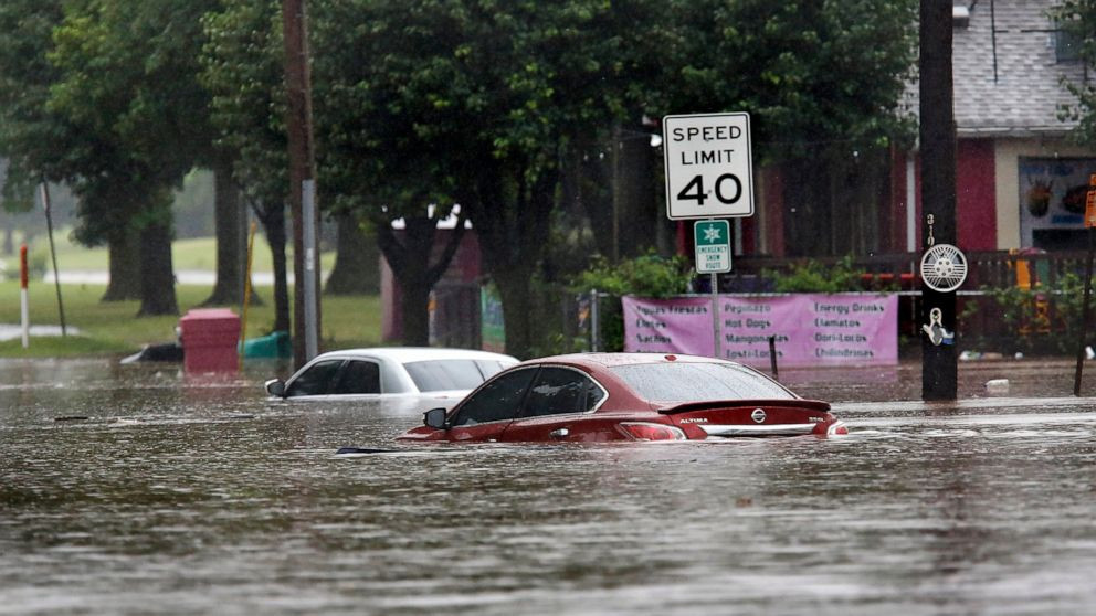
A stationary band of rain in New Orleans is increasing the flood threat across the metro this morning. Flooding will be possible through the holiday weekend along the Texas and Louisiana Gulf Coast.
The WeatherRadar shows a nearly stationary band of heavy rain across the New Orleans metro this morning. Flooding is a concern as this heavy rain will continue through midday. Remember to avoid water-covered roads and to turn on your app alerts.
New Orleans isn't the only area along the Gulf Coast at risk for flooding as we head into Labor Day Weekend. Heavy rain will bring a flooding threat from Galveston, Texas, to Biloxi, Miss. Folks traveling to Houston, Beaumont, Texas, Lake Charles, La., and New Orleans should be ready for downpours.
Those traveling by road this holiday weekend, especially those driving on I-10, should keep an eye on the WeatherRadar. Also, did you know that Weather & Radar is available on Android Auto? Learn more here.
New Orleans Issues Flash Flood Warning
The Flash Flood Warning is in effect until 12:15 p.m.
The storms have already dropped up to two inches of rain and another two inches of rain are possible.
This also includes Interstate 10 between mile markers 225 and 245 and Interstate 610 mile markers 1 and 4.
Drivers are urged to not drive through any flooded roads.
New Orleans has issued neutral ground parking until 10 p.m.
Baton Rouge Braces for Heavy Rain
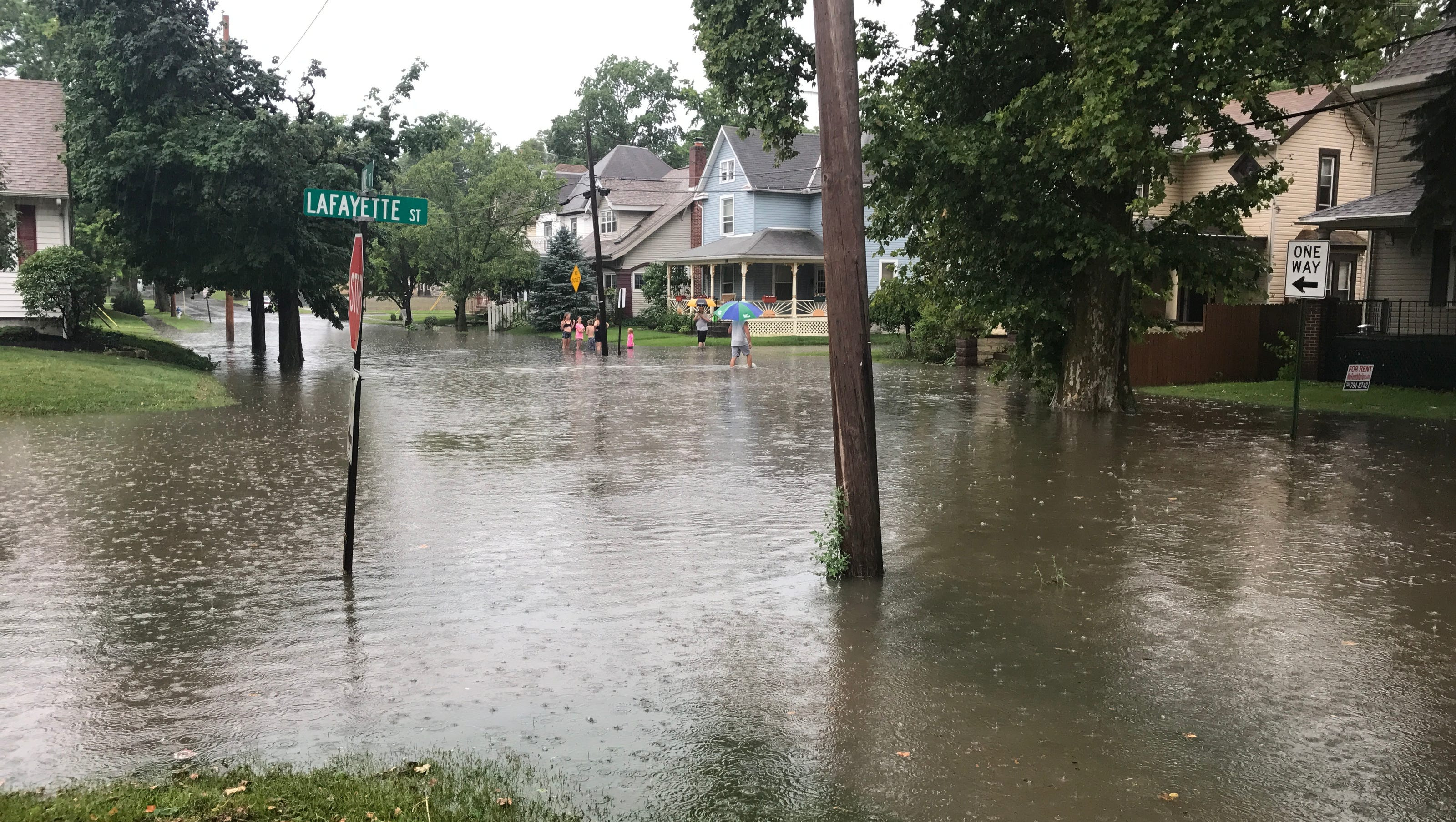
A FLOOD WATCH is in effect for Baton Rouge and areas to the south and east through Friday Evening. Excessive runoff may result in flooding of small creeks and other low-lying and flood-prone locations. Flooding may occur in poor drainage and urban areas. Storm drains and ditches may become clogged with debris. Monitor the forecast and be alert for possible Flood Warnings. Those living in areas prone to flooding should be prepared to take action should flooding develop.
Baton Rouge Forecast
Today & Tonight: Mostly cloudy skies will dominate Friday with rain showers passing through the Capital Area in an on-and-off fashion for the majority of the day. Most will see rain on Friday so grab your raingear before heading out the door. Storms may begin as early as 7am and last through the evening commute hours for some. There will still be dry time between the rain showers but thanks to the cloud cover, temperatures will remain in the low to mid-80's all afternoon. Tonight, radar activity will die down by sunset but a few isolated storms are possible into the overnight hours.
Baton Rouge Weekend Outlook
Up Next: Saturday will bring a continuation of the active weather pattern. Mostly cloudy skies will give way to numerous showers and thunderstorms. Like the end of the week, high temperatures will be limited to the middle 80s. Showers are likely to begin even earlier than previous days, so check the radar before heading out for any early Saturday morning activities. Sunday, moisture and storm energy will drift slightly lower, not enough to eliminate isolated showers and thunderstorms. By the end of the weekend, an additional 1-4 inches of rain is expected in addition to what has fallen through Thursday. If there is a drier period in the Storm Station 7-Day Forecast, it would be found Monday and Tuesday. While showers will not shut down entirely, relatively drier and more stable air will cut them down in number.
Staying Safe in the Rain
If you have plans for the Labor Day Weekend, nearby coastal communities will have similar weather to the Baton Rouge area. Be alert to darkening skies as it could signal thunderstorms. Lightning could chase you inside briefly, but do not expect any washouts. For LSU Football fans traveling to Las Vegas it will be downright hot. Afternoon temperatures on gameday will soar well into the 100s and postgame temperatures will still be in the 90s.
The Tropics
Two areas of disorganized showers and thunderstorms are currently being monitored for tropical development in the eastern Atlantic. One currently has a better chance (50%) for tropical development in the next 7 days while the other has a low chance as of Friday morning.
Looking Ahead
Good chance of staying wet through at least Monday
Good chance of staying wet through at least Monday
The latest breaking updates, delivered straight to your email inbox.
Good chance of staying wet through at least Monday
Thursday's Planner
Scattered showers and thunderstorms will be likely this afternoon with temperatures in the low to mid 80s.
Good Rain Chances Ahead
Our rain chances will remain high through at least Sunday, with the highest chances being on Saturday at 90%.
Scattered showers and thunderstorms will again be possible starting late Friday morning, before becoming more numerous during the afternoon and evening.
WDSU First Warning 7 Day Forecast
Our weather conditions look to stay wet through the weekend, before getting a break in the rain on Labor Day Monday and again Tuesday. High temperatures will be mainly in the mid to upper 80s with lows in the mid to upper 70s.
Wrapping Up: Staying Weather-Wise
The Storm Station is here for you, on every platform. Your weather updates can be found on News 2, wbrz.com, and the WBRZ WX App on your Apple or Android device. Follow WBRZ Weather on Facebook and Twitter for even more weather updates while you are on the go.
Remember, stay safe during this period of heavy rain and flooding. Keep an eye on the latest weather forecasts and be prepared for potential power outages or road closures. If you need to travel, be aware of your surroundings and avoid flooded roads.
Stay informed, stay safe, and enjoy the rest of your weekend.