Less than 10 days after Hurricane Helene made landfall in Florida, the state is bracing for another potentially devastating blow from a hurricane in the Gulf of Mexico, this one a potential Category 3 storm.
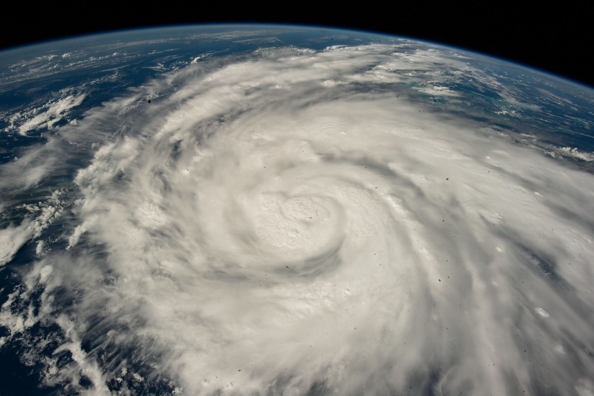
Tropical Storm Milton formed in the western Gulf on Saturday morning, just hours after it became a tropical depression, the National Hurricane Center said in a special alert. The 13th named storm, which uses the letter M, is running ahead of pace – it doesn’t usually occur until October 25.
Milton is forecast to strengthen and bring life-threatening impacts to portions of the west coast of Florida next week. With very low vertical wind shear and incredibly warm sea-surface temperatures, Milton will be able to gain steady to rapid strength over the next few days.
“The official intensity forecasts call for Milton to become a hurricane in about 36 hours, and a major hurricane by 72 hours,” according to an update from the National Hurricane Center.
The storm is expected to “quickly intensify while it moves eastward to northeastward across the Gulf of Mexico and be at or near major hurricane strength when it reaches the west coast of the Florida Peninsula mid week,” the hurricane center said. As of Saturday afternoon, it is projected to make landfall in Florida at up to Category 3 strength, with 115 mph winds.
Major hurricane is a term designated for hurricanes of Category 3 strength or greater on the Saffir-Simpson Scale. For a hurricane to become a Category 3 storm, winds at its center must be sustained at 111 mph.
Hurricane watches, as well as storm surge watches, will likely be issued for portions of the Florida coast on Sunday – a dangerous storm surge is expected for some areas just affected by Helene.
In preparation for the storm, Republican Gov. Ron DeSantis declared a state of emergency for 35 counties Saturday, according to a release from his office.
“Regardless of development, locally heavy rains could occur over portions of Mexico during the next day or two, and over much of Florida late this weekend through the middle of next week,” the NHC said.
The storm threat comes after Helene made landfall September 26 on Florida’s Big Bend as a Category 4 and created a 500-mile path of destruction with catastrophic flooding, damaging winds and power outages. Local authorities have reported more than 200 deaths across six states and fear the number could rise.
Helene was one of the largest storms the Gulf of Mexico has seen in the last century.
The latest storm forecast at this point calls for widespread totals of 4 to 6 inches of rain across almost the full length of the state, from Gainesville down through Key West, with isolated higher amounts up to 10 inches possible through Thursday. Tampa has already seen more than 20 inches of rainfall above normal for the year. Cities like Melbourne, Jacksonville, Naples and Fort Myers all have more than a foot of surplus rainfall so far this year as well.
There is also an increasing risk of storm surge for the western Florida Peninsula as early as late Tuesday or Wednesday. Damaging winds, tornadoes and waterspouts will also be possible next week.
The hurricane center is warning people in Mexico’s Yucatan Peninsula, the Florida Peninsula, the Florida Keys, as well as the Bahamas to closely monitor this system this weekend and early next week for any impacts.
Tracking Hurricane Milton: A Storm Forming in the Bay of Campeche
Tropical Storm Milton — the 13th named storm in the 2024 hurricane season — has formed and is forecast to become a major hurricane before hitting Florida next week.
Milton is forecast to intensify while moving northeastward toward Florida’s Gulf Coast and could make landfall Wednesday as a Category 3 hurricane or stronger, the National Hurricane Center reported Saturday afternoon. Milton strengthened from a depression into a tropical storm within hours Saturday, reaching sustained winds of 40 miles per hour. As of 5 p.m., the storm was located over the southwestern Gulf of Mexico.
Tampa Bay could see tropical storm-force winds as early as Tuesday. There could be a “risk of life-threatening impacts” including storm surge, wind and flash flooding along parts of Florida’s Gulf Coast, the National Hurricane Center said in its 11 a.m. advisory. Heavy rainfall is expected ahead of the storm on Sunday and Monday, which could be “at or near major hurricane strength” before landfall.
Predictions of the track likely will continue to shift in the coming days. The forecast cone suggests the eye of the storm could make landfall somewhere along Florida’s west coast, which includes Tampa Bay. If the storm tracks northward, it could mean stronger intensification as the system has more time to sit over warm Gulf waters, forecasters said. But the storm’s effects could be felt beyond its landfall, reaching areas already devastated by Hurricane Helene last month.
The Threat of Flooding and the Legacy of Hurricane Helene
Austen Flannery, a meteorologist at the National Weather Service in Tampa, said it’s critical for those impacted by Helene to pay attention to this storm and prepare if necessary.
“There’s debris, there’s all sorts of stuff that hasn’t been cleaned up. There’s a lot of structures that are really probably not safe to be in for another storm,” he said. “What we’re forecasting is not good for our coastal communities.”
The National Hurricane Center had warned those in the Yucatan peninsula of Mexico, the Florida peninsula, the Florida Keys and the northwestern Bahamas to monitor the storm’s progress in an update earlier Saturday morning.
Another wave of moisture is expected to drench Tampa Bay before the storm makes landfall, according to the National Weather Service. That creates a risk for flooding even before the storm arrives and increases the potential for inland flooding because the land already is saturated.
Tampa Bay is forecast to see between five to eight inches of rain over the next five days, with some local areas potentially seeing up to 12 inches. But that could change depending on how quickly the storm develops.
“We’re expecting impacts all along the coast, and that would be anything from storm surge to strong winds and flooding rain,” said National Weather Service meteorologist Christianne Pearce. “Rainfall ahead of the storm would definitely have more of an impact because that means any extra rainfall from the storm would lead to even more flooding,”
Preparing for the Storm: Sandbags and Emergency Supplies
The National Hurricane Center is tracking two other hurricanes in the Atlantic, although neither appears to pose a major threat to Florida.
Local governments, including Tampa, St. Petersburg and Hillsborough, Pinellas and Pasco counties, are offering sandbags for residents ahead of the storm.
Hurricane season runs until Nov. 30.
A Season of Unprecedented Activity: What's Next?
5 things to know about the 2024 hurricane season, according to forecasters.
Forecasters predict ‘extremely active’ 2024 hurricane season. Here’s why.
Could Tampa Bay flood insurance rise after a hurricane? A warning from Hurricane Ian
Want to know what areas are flooding in Tampa Bay? Here’s where to look.
Checklists for building all kinds of storm kits.
Shreya Vuttaluru is a data reporter on the investigative team. Reach her a [email protected].
The Tampa Bay Times e-Newspaper is a digital replica of the printed paper seven days a week that is available to read on desktop, mobile, and our app for subscribers only. To enjoy the e-Newspaper every day, please subscribe.