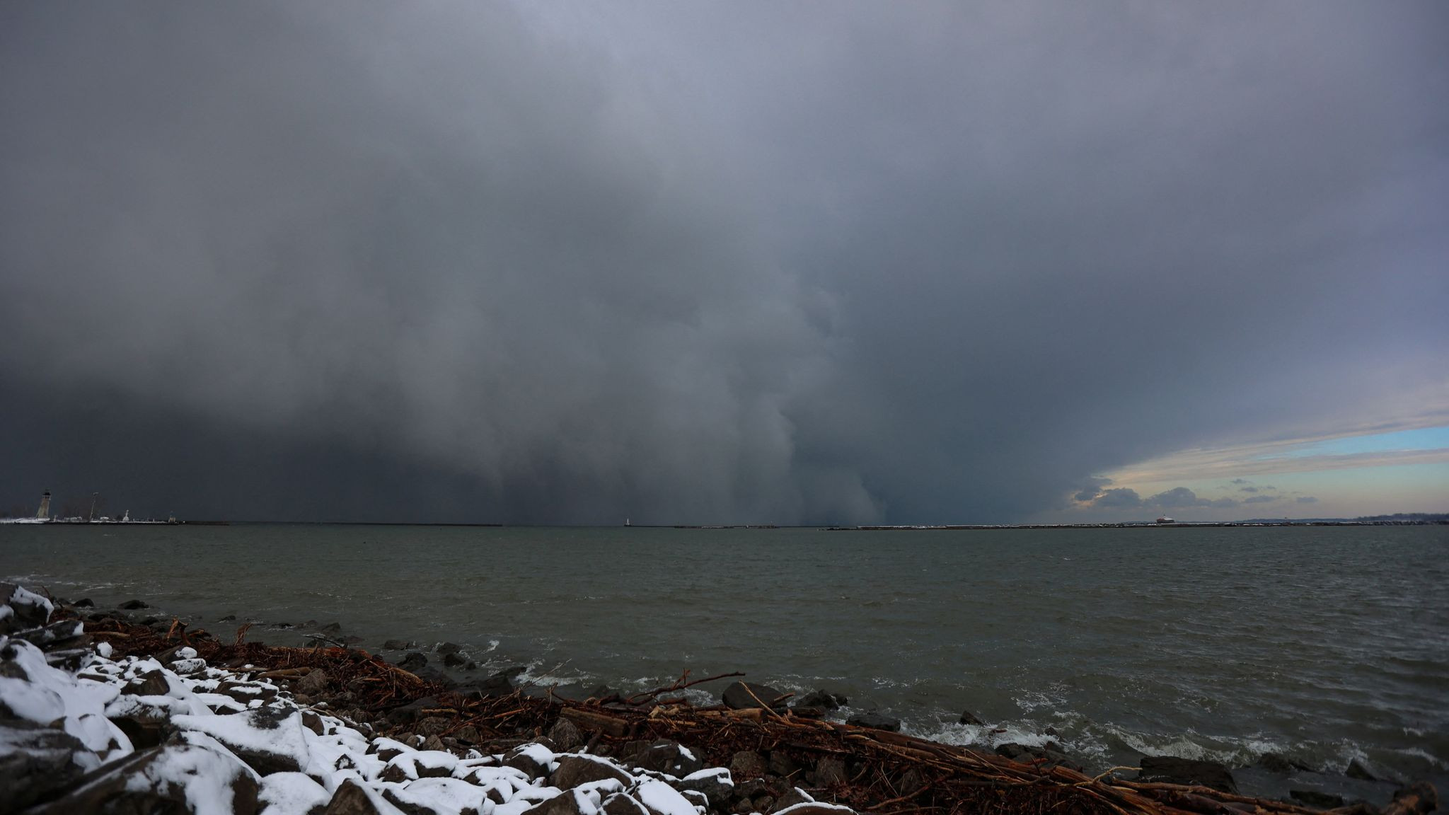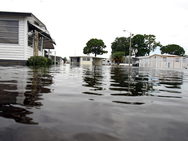
Tropical Storm Debby has strengthened into a Category 1 hurricane as it rapidly approaches Florida, where it is expected to make landfall in the Big Bend region early on Monday. Hurricane-force winds are “very near landfall” with the storm’s center expected to reach the Big Bend later this morning, according to the National Hurricane Center. The storm has maximum sustained winds of 80mph (130kph) and was about 45 miles west-northwest of Cedar Key as it moved north at 12 mph (19 kph) at approximately 5.00am EDT. The storm will bring “life-threatening” storm surge of up to 10 feet along Florida’s Gulf Coast. The southeast US could also historic levels of rainfall this week, the National Weather Service said. Some areas of Georgia and South Carolina could see up to 30 inches of rain through Friday, while Florida could see up to 18 inches throughout the week, according to the NWS. Debby will travel across Florida before blowing through southern Georgia on Tuesday. The storm is forecasted to hit South Carolina Wednesday through Friday before calming. Governor Ron DeSantis has placed more than 60 of Florida’s counties under a state of emergency as the storm approaches. “Just because you are not in the eye of the storm doesn’t mean you’re not going to have major, major effects,” he said. The National Weather service has given a new tornado watch update which predicts almost 11.7m Florida and Georgia residents could be exposed to tornadoes. The alert issued at 6.00am EDT covers areas ranging from Sarasota, Florida, to Savannah, Georgia. The regions are also exposed to 70mph isolated gusts, although no hail is expected. Additionally, 2,287 schools and 158 hospitals are potentially in the path of tornadoes. The alert is in effect until 4.00pm EDT. Hurricane Debby has now strengthened to a Category 1 storm as it charts a path towards the Florida Big Bend region, where it is expected to make landfall on Monday morning. The National Hurricane Center warned that, as of around 5am ET, Debby has sustained winds of up to 80mph and is located just 40 miles from Cedar Key. The hurricane is expected to bring life-threatening storm surge when it makes landfall in Florida’s Big Bend around the Steinhatchee area, before it then pushes northeastward through the state. There is also the risk of floods and tornadoes. Myriam Page has the story. Hurricane Debby is expected to make landfall in Florida on Monday morning bringing life-threatening storm surge The National Weather Service has issued several watches and warnings throughout the southeast US as Tropical Storm Debby approaches. A warning, such as a Hurricane Warning or Storm Surge Warning, means residents should take immediate protective action. “A warning means weather conditions pose a threat to life or property,” the NWS writes. Meanwhile, a watch means residents should prepare for extreme weather. These may be issued when meteorologists don’t know the exact timing and severity of the event. “ People should have a plan of action in case a storm threatens and they should listen for later information and possible warnings especially when planning travel or outdoor activities,” the NWS writes. The National Hurricane Center has warned that the center of Hurricane Debby is due to hit the Big Bend coast “later this morning”. The storm continues to hurtle towards the north-northeast at approximately 12 mph, according to a 5.00am update from the NHC. It has warned of a “danger to life” situation due to a conflation of hurricane-force winds, storm surge and rising tides. Debby is expected to hit the Georgia coast by Tuesday evening. More than 120,000 homes and businesses have been left without power across Florida, according to data from PowerOutages.com. Hurricane-force winds are battering parts of the Sunshine State, as north-central regions face the brunt of the harsh conditions. The storm is nearing landfall with its eyewall moving onshore toward the Big Bend. Some northern counties – including Gilchrist and Dixie – are experiencing approximately 30 per cent outage rates, according to the website. Hurricane Debby is nearing landfall with its eyewall moving onshore toward the Big Bend, Doppler radar images from Tallahassee obtained by the National Hurricane Center suggest. Winds have clocked in at up to 80 mph, according to an update at 4.00am EDT from the National Hurricane Center. The storm is about 40 miles west-northwest of Cedar Key, 80 miles south-southeast of Tallahassee and is continuing to moving to the north-northeast at 12 mph. The National Oceanic and Atmospheric Administration has warned of “life-threatening storm surge” and “potentially catastrophic rainfall”. ## Rapid Intensification: A Trend in a Warming World Hurricane Debby rapidly intensified ahead of its landfall in Florida, joining a growing list of recent storms to accomplish the feat, as the planet warms and stacks the deck in favor of strengthening storms. Rapid intensification is exactly what it sounds like: A storm increasing in strength over a short period of time. But a storm can’t be considered a rapid intensifier unless its winds increase by 35 mph in 24 hours or less, a feat Debby accomplished early Monday before landfall. The storm strengthened from a 45 mph tropical storm at 2 a.m. on Sunday to an 80 mph hurricane at 2 a.m. Monday. Storms need a few basic ingredients to strengthen: warm water, warm, moist air, and favorable upper-level winds that won’t rip it apart. Debby had one of those ingredients in abundance. The storm tracked through near-record warm water temperatures in the eastern Gulf of Mexico. This provided ample fuel for the storm to tap into and rapidly intensify, despite having to fight off some dry air and hostile upper-level winds. Recent observations show extensive warmth in the eastern Gulf of Mexico, where 31+°C waters are two or more degrees above normal. The energy these warm waters provide, alongside weak vertical wind shear, support the NHC’s 11am EDT 4 August forecast for Debby to rapidly intensify. https://t.co/jH8NelEuen pic.twitter.com/MHP3rIwedC Ocean temperatures in the North Atlantic have been record or near-record warm since last year. More than 90% of warming around the globe over the past 50 years has taken place in the oceans, according to the National Oceanic and Atmospheric Administration. This warming, caused by fossil fuel pollution, is making rapid intensification more likely, and more and more storms are doing it as they approach landfall, making them harder to prepare for. ## The Storm’s Impact on Florida Hurricane Debby is already is impacting parts Florida, Gov. Ron DeSantis said Monday morning. “We have seen significant storm surge, we have seen inundation, we have seen and will continue to see flooding in various part of Florida,” DeSantis said. “This storm is expected to move throughout north, central Florida, and likely go into Georgia and the Carolinas.” ## Debby Makes Landfall Near Steinhatchee Hurricane Debby just made landfall as an 80 mph Category 1 storm in Florida’s Big Bend region, a sight that’s all too familiar for residents there. The landfall location near Steinhatchee, Florida, was just 9 miles southeast of where Category 3 Hurricane Idalia made landfall nearly a year ago at 7:45 a.m. on August 30. Hurricane Debby has been bringing heavy rainfall, high wind gusts and storm surge along the west coast of Florida since Sunday night. On Monday morning, it made landfall near Steinhatchee with winds of 80 mph, according to the National Hurricane Center at 7 a.m. EDT. The landfall is within 20 miles of Hurricane Idalia’s landfall, which also came ashore in the Big Bend of Florida in August 2023 as a Category 3 hurricane with 125 mph winds. Now that the storm has made landfall, weakening will begin, and Debby should become a tropical storm by early afternoon as the center of the storm nears the Georgia line. ## A String of Watches and Warnings are in Effect: Hurricane Debby has made landfall in Florida near Steinhatchee with winds of 80 miles per hour, according to the National Hurricane Center at 7 a.m. EDT. The landfall is within 20 miles of Hurricane Idalia’s landfall, which also came ashore in the Big Bend of Florida in August 2023 as a Category 3 hurricane with 125 mph winds. Now that the storm has made landfall, weakening will begin, and Debby should become a tropical storm by early afternoon as the center of the storm nears the Georgia line. The storm is forecast to slowly move toward and along the Southeast coast in the next couple of days, bringing life-threatening and potentially historical rainfall totals across parts of Florida, Georgia and South Carolina. ## Power Outages and Flight Cancellations Power outages in Florida impacted more than 200,000 customers Monday morning as Hurricane Debby made landfall along the Big Bend region of Florida. More than 213,000 customers were without power, according to the tracking website PowerOutage.us. That includes nearly half of the electric customers in Dixie and Taylor counties, the areas nearest the hurricane’s landfall. Hundreds of flights were canceled or delayed Monday. Several airports were impacted, according to FlightAware, including: * Miami International Airport * Fort Lauderdale-Hollywood International Airport * Hartsfield-Jackson Atlanta International Airport While not within the storm’s direct path, Miami International Airport, Fort Lauderdale-Hollywood International Airport and Hartsfield-Jackson Atlanta International Airport are all seeing cancellations and delays this morning. ## How Hurricanes are Named Hurricanes are named using every letter of the alphabet, except q, u, x, y and z. There are six lists of names that are in rotation — the names used this year will be used again in 2030. But, if a storm is so impactful it will be remembered for years to come, the name is retired. For example, there will never be another Hurricane Katrina. Related article Ever wonder how hurricanes are named? CNN's meteorologist explains | CNN ## Storm Surge Rises in Florida Storm surge is rapidly piling up on shore in Florida’s Big Bend region as Hurricane Debby is nearing landfall. Water levels at Cedar Key, Florida, about 25 miles from where Debby is about to make landfall, is measuring around 5.5 feet of storm surge (the height of the water level above normal tide). High tide was supposed to occur around 4 a.m. at Cedar Key, but Debby’s powerful winds pushing onshore has caused the water level to rise by about a foot since then. Water levels may continue to rise more in the next couple of hours as the storm’s wind continue to be onshore. The eyewall of Debby is moving onshore and landfall in the Florida Big Bend is expected within a couple of hours, according to the National Hurricane Center’s 5 a.m. ET update. Debby has winds of 80 mph and is now moving north-northeast at 10 mph, 2 mph slower than the update last hour. Florida’s Big Bend coastline is seeing the worst of Debby’s conditions now as the eye passes. Numerous reports of sustained tropical-storm-force winds have been made, but the strongest so far is in Horseshoe Beach, where a weather station recently recorded a sustained wind of 65 mph and gusts of up to 95 mph. ## Catastrophic Flooding Potential: Debby’s forward speed is expected to slow even more after landfall, and there is high confidence that the storm’s slow movement over the Southeastern US will result in catastrophic flooding in some locations, dropping months’ worth of rain in the next several days. ## Hurricane Debby Nears Landfall Hurricane Debby is nearing landfall, with the eyewall moving onshore in the Florida Big Bend area, according to a special 4 a.m. ET update from the National Hurricane Center. Landfall is when the center of the eye moves over land. Debby has sustained maximum winds of 80 mph, with stronger gusts. It is about 40 miles west-northwest of Cedar Key, 80 miles south-southeast of Tallahassee, Florida, and is moving to the north-northeast at 12 mph. More than 100,000 homes and businesses are without power across Florida as Debby’s hurricane-force winds begin to batter the state, according to PowerOutage.com. The majority of outages are in north-central Florida, including Levy and Suwannee counties. ## What to Expect Along Debby’s Path Hurricane Debby is bringing gusty winds and life-threatening flooding across Florida early Monday. After making landfall in Florida’s Big Bend later Monday morning, the storm is expected to push northeastward, where Georgia and South Carolina are bracing for severe weather. Here’s what to expect along Debby’s path: ## Near Steinhatchee, Florida (in potential landfall area): * Sustained winds of 80 mph with gusts up to 100 mph. * Storm surge of 6 to 10 feet. * Rainfall totals of 10 to 15 inches. ## Tallahassee, Florida * Sustained winds of 45 to 55 mph with gusts up to 70 mph. * Storm surge of 2 to 4 feet. * Rainfall totals of 10 to 15 inches. ## Jacksonville, Florida * Sustained winds of 35 to 45 mph with gusts up to 55 mph. * Storm surge of 1 to 2 feet. * Rainfall totals of 6 to 10 inches. ## Savannah, Georgia * Sustained winds of 30 to 40 mph with gusts up to 50 mph. * Storm surge of 1 to 2 feet. * Rainfall totals of 10 to 15 inches. ## Charleston, South Carolina * Sustained winds of 25 to 35 mph with gusts up to 45 mph. * Storm surge of 1 to 2 feet. * Rainfall totals of 6 to 10 inches. ## Debby’s Hurricane-Force Winds Hurricane Debby is now packing maximum sustained winds of 80 mph and is just 40 miles west of the Floridian island of Cedar Key, the National Hurricane Center said in an advisory at 2 a.m. ET. The storm is forecasted to reach 85 mph before it slams into the coast Monday morning. Though Debby has yet to make landfall, its hurricane-force winds extend outward up to 45 miles from the center and tropical-storm-force winds stretch for up to 140 miles, according to the hurricane center. This means strong winds and heavy rains are already bringing hazardous conditions to some areas, including flooding and debris-covered roads. St. Petersburg has seen over a month’s worth of rainfall — 9.89 inches — in the last 48 hours, eclipsing its August average of 8.39 inches, the hurricane center said. More than 11 inches of rain have been reported in Pinellas Park and Palm Harbor. ## Watches and Warnings are in Effect: * A hurricane warning remains in effect for portions of the Florida Big Bend and the Florida Panhandle from just south of the Ochlockonee River to Mexico Beach. * A tropical storm warning is in effect for the remainder of the Florida Big Bend, from the Ochlockonee River to the Aucilla River, and for the Florida Panhandle, from Mexico Beach to the Alabama-Florida border, including the Apalachicola River. * A tropical storm warning is in effect for a portion of the Florida Gulf Coast, from the Aucilla River to Bonita Beach, including the Florida Keys. * A tropical storm warning is in effect for the Dry Tortugas. * A tropical storm watch is in effect for the Florida Panhandle, from the Alabama-Florida border to the Okaloosa-Walton County line. ## Flooding is the Main Threat The main threat will be flooding, both from storm surges and heavy rainfall. Freshwater flooding, which is caused by rainfall, has become the deadliest impact of tropical systems in the last decade, according to the hurricane center — a threat made more dangerous as the world warms from fossil fuel pollution. ## High-Water Rescues in Pinellas County High-water rescues were underway Sunday night in Pinellas County, Florida, as incoming Hurricane Debby whipped up heavy rains, storm surge and dangerous flooding, emergency officials said. Emergency crews in the county, which includes the cities of Clearwater and St. Petersburg, were fielding very high volumes of 911 calls Sunday night. A flash flood warning has been issued for more than 2 million people across an area that includes the Pinellas, Manatee and Sarasota counties, as well as parts of Hernando and Hillsborough counties, the National Weather Service said. Between 5 to 10 inches of rain have fallen in the area and as many as four more inches are possible. The Sunshine Skyway Bridge — a key transportation artery in Lower Tampa Bay — has been closed “due to high winds and inclement weather,” the Florida Highway Patrol announced. The Clearwater Police Department has also reported debris on roadways, down trees and flooded parking lots. ## Debby is the Fourth Named Storm Debby is the fourth named storm of the Atlantic hurricane season and the second named hurricane. Debby’s arrival continues to cement an exceptionally early start to the hurricane season after Hurricane Beryl tore through the Caribbean and Texas last month as the earliest Category 5 Atlantic hurricane on record. The second Atlantic hurricane does not occur, on average, until August 26. ## School Closures School systems in Florida and Georgia have announced closures ahead of Hurricane Debby’s landfall. Florida State University, Florida A&M University, University of Florida, University of North Florida, and University of South Florida will be closed on Monday, according to the Florida Department of Education. About two dozen K-12 school systems in the state have announced closures for Monday, including Duval County Public Schools and Leon County Schools. Several school systems in Georgia have also announced closures. Savannah-Chatham County Public School System will have a half-day on Monday, and will be closed on Tuesday and Wednesday, according to its website. Long County Schools has announced that schools will be delayed until Thursday due to the storm. Savannah State University and Georgia Southern University have also suspended operations. ## Debby Strengthens to Category 1 Debby, the fourth named storm of the Atlantic hurricane season, has become a Category 1 storm, according to the National Hurricane Center. The storm, located about 100 miles west-northwest of Tampa, Florida, with maximum sustained winds of 75 mph, is expected to make landfall in Florida’s Big Bend region Monday morning. “Debby is then expected to move slowly across northern Florida and southern Georgia Monday and Tuesday, and be near the Georgia coast by Tuesday night,” the hurricane center said in its 11 p.m. ET advisory. Debby began dumping rain on parts of the state earlier Sunday as a tropical storm and is expected to unload potentially historic amounts of rainfall over the southeastern United States. Debby is the second hurricane of the 2024 Atlantic hurricane season after Hurricane Beryl hit Texas last month. On average, the second hurricane does not occur in the Atlantic until August 26th, as 2024 continues to pace ahead of normal. ## States of Emergency Florida Gov. Ron DeSantis, Georgia Gov. Brian Kemp and South Carolina Gov. Henry McMaster have declared states of emergency ahead of Hurricane Debby’s landfall. DeSantis said Sunday that he’d activated the Florida National Guard so it would be poised to assist with humanitarian needs as well as search and rescue. DeSantis called on residents to finish their preparations and to brace for power outages, “particularly in parts of the state like here in Tallahassee.” “There’s going to be a lot of trees that are going to fall down. You’re going to have debris. You are going to have power interruption,” the governor said, “so just prepare for that.” DeSantis also urged Florida residents to avoid floodwaters ahead of the storm’s potentially significant flooding impacts, particularly in North Central Florida. “Please do not drive your vehicles through flooded streets. The number one way we have fatalities as a result of floods is people trying to drive through the floodwater,” he said. ## The Role of Climate Change in Hurricane Debby Hurricane Debby’s alarming rainfall potential is exactly the kind of forecast scientists say is more likely in a world warming due to fossil fuel pollution. As Earth’s atmosphere warms, it can hold more moisture — 7% more for each degree Celsius increase in warming — which it can then wring it out in more intense spurts. Scientists say this is happening in hurricanes, too, and also increasing the total amount of rain the storms can produce. A study in the wake of the 2020 hurricane season, the most active on record, found hourly rainfall rates in all storms were made 5 to 10% more extreme by global warming, with an even more substantial impact on hurricanes. ## Debby’s Slow Movement Debby is forecast to slow down enough that the storm will essentially park itself over the southeastern United States for multiple days, ringing out potentially historic amounts of rain in the process. This dangerous wrinkle in the forecast might seem unusual, but it’s part of a trend in recent years as the planet’s atmosphere warms due to fossil fuel pollution. The forward speed of tropical cyclones — the all-encompassing term for tropical storms, hurricanes, typhoons — slowed by 10% globally between 1949 and 2016, a 2018 study found. There is some variation among ocean basins. The study found a 20% to 30% slowdown over land areas affected by North Atlantic and North Pacific tropical cyclones, respectively. Tropical cyclones have slowed more in the Northern Hemisphere, which is significant because that is where a majority of storms occur each year. There have been notable examples of this in recent years including 2018’s Hurricane Florence and 2017’s Hurricane Harvey, which broke the rainfall record for any US tropical cyclone when it unleashed more than 60 inches of rain on Texas. ## Record Rainfall Potential Weather Prediction Center forecasters have issued rare high risk forecasts for Debby’s rain over the Southeast in what is one of the most serious signs of the storm’s flood potential. Storm rainfall totals of 10 to 20 inches are expected throughout the week as the system slows down. Some localized spots could see 30 inches of rain. This prompted the WPC to issue level 4 of 4, or high risks, for flooding rainfall. Level 4 of 4 risks are only issued on about 4% of days annually but account for 39% of flood-related fatalities and 83% of flood-related damages in the continental US. Freshwater flooding, which is caused by rainfall, has become the deadliest aspect of tropical systems in the last decade, according to the Hurricane Center — a threat made more dangerous as the world warms from fossil fuel pollution. ## Unprecedented Amounts of Rain Expected As a slow-moving Hurricane Debby churns along the Georgia-Carolina coastline heading into the new week, it could lead to seemingly endless amounts of rain for days, with totals potentially reaching over 2 feet. The heaviest rain amounts could even top 30 inches or more, depending on how long Debby meanders, with some forecast models showing the storm could linger through at least Thursday. “This rainfall will likely result in areas of considerable flash and urban flooding, with significant river flooding expected,” the National Hurricane Center said. The cities of Savannah, Georgia, and Charleston, South Carolina, could both be drenched with a month’s worth of rain in a single day — and perhaps even an entire summer’s worth of rain over the course of the storm. Potentially historic: Such exceptional rainfall would challenge state records for rain from a tropical cyclone: In Georgia, the record is 27.85 inches from 1994’s Alberto, while South Carolina’s record is 23.63 inches from Florence in 2018. ## Storm Surge Threat With an uptick in the intensity forecast comes an increase in forecasted storm surge, which occurs when ocean water is pushed inland by the onshore winds of a hurricane. Storm surge flooding above ground could rise to 6 to 10 feet along Florida’s Big Bend, and coastal Georgia and South Carolina could see surges reach 2 to 4 feet. ## The Role of Climate Change A warmer atmosphere holds more moisture and can dump heavier rain. Warmer oceans can fuel stronger hurricanes, packing a punch with higher storm surge thanks to sea-level rise. Warmer air and ocean temperatures fueled by human-induced climate change can lead to wetter tropical systems. ## Disaster Declaration for Florida US President Joe Biden authorized a disaster declaration for Florida on Sunday as Debby swept across the state ahead of strengthening to a hurricane. “The President’s action authorizes the Department of Homeland Security, Federal Emergency Management Agency (FEMA), to coordinate all disaster relief efforts which have the purpose of alleviating the hardship and suffering caused by the emergency on the local population, and to provide appropriate assistance for required emergency measures,” his declaration read. ## A Familiar Blow for Florida’s Big Bend Florida’s Big Bend area is still recovering from a devastating blow by Category 3 Hurricane Idalia last August. Idalia caused “significant damage” after it ripped into Florida with 125 mph winds and record-setting storm surge. National Hurricane Center forecasts called for Idalia to rapidly intensify and strengthen all the way up to landfall. And for 24 hours, that proved to be true. The hurricane’s winds increased by 55 mph, pushing Idalia into a 130-mph, Category 4 – a rate of intensification so exceptional it ranks in the top 0.4% of Atlantic storms since 1982, according to NOAA research meteorologist John Kaplan. The storm left more than 100,000 Floridians without power, set new records for surge and triggered mandatory evacuation orders across the state. ## Preparing for Hurricane Debby Florida Gov. Ron DeSantis declared a state of emergency for most of the state’s 67 counties to mobilize resources as storm Debby churned toward the Sunshine State. “Floridians are encouraged to monitor weather conditions, listen to all orders from local officials, create disaster preparedness plans, and stock disaster supply kits with food, water, and other necessities for their households,” the governor’s office said on Friday. Sandbag distribution began last week for residents in several communities in the Orlando and Tampa metro areas. Multiple counties in the state’s panhandle – including Escambia, Okaloosa and Santa Rosa – started distributing sandbags on Thursday. Hurricane Center Director Michael Brennan urged residents to prepare multiple days of food, water and prescription medicines. “Keep your gas tank full, cash on hand, and keep batteries,” he said. “Make sure your phone’s charged and make sure you have a battery powered radio.” © 2024 Cable News Network. A Warner Bros. Discovery Company. All Rights Reserved. CNN Sans ™ & © 2016 Cable News Network.

Luca Rossi
Environmental Reporter
Reporting on environmental issues and sustainability.