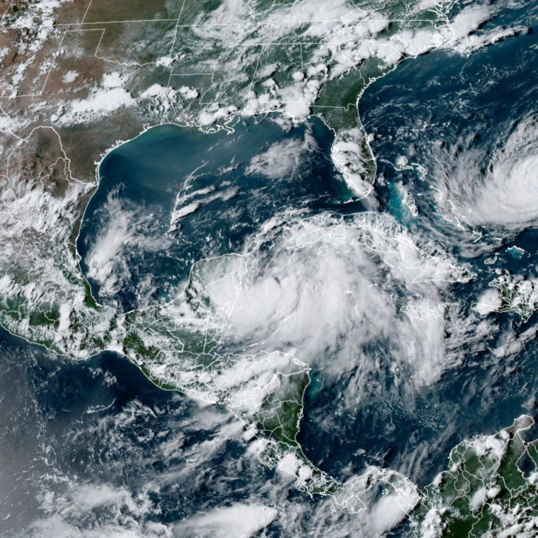
As Hurricane Milton continues to move away from Florida and Georgia, many residents in the impacted areas are keeping a wary eye out for what’s next. October may seem like it’s late in the year for tropical storm activity, but there are still six weeks to go in hurricane season, and forecasters are keeping a close watch of any disturbances that may develop.
The US Weather Department, along with tracking Hurricane Milton, has its eyes on two additional disturbances in the Atlantic Ocean.
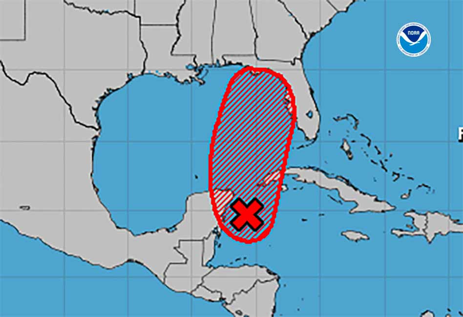
One of these has a minimal chance of forming in the Eastern Tropical Atlantic. However, a second system, brewing about 300 miles from Bermuda and along Florida’s east coast, has been catching attention.
If this system forms into a tropical storm, it would be named Nadine, making it the 14th named storm of the 2024 Atlantic hurricane season, potentially bringing heavy rains and gusty winds to Bermuda. Despite initial concerns, the National Hurricane Center (NHC) has some reassuring news.
According to The New York Post, the system has only a small chance of developing into a tropical storm. NHC forecasters currently give it a 30 per cent chance of evolving into a hurricane within the next 48 hours. For context, a tropical hurricane is marked by maximum sustained winds of 39 to 73 mph, while a hurricane is classified as anything above 74 mph. Even if this disturbance strengthens into Nadine, it doesn’t necessarily mean it will intensify into a hurricane.
“Environmental conditions are becoming less favourable for tropical or subtropical development today (Wednesday) while the low moves northeastward to east-northeastward at around 15 mph,” the National Hurricane Center stated. The centre added, “Upper-level winds are expected to become too strong for further development tonight or on Thursday.”
In essence, this system is heading out to sea, which means Americans can breathe a sigh of relief. “It’s going straight out to sea, it wouldn’t affect anybody,” meteorologists from Fox Weather shared with The New York Post.
Hurricane Milton slams Florida
Hurricane Milton, described by President Joe Biden as “the storm of the century,” struck near Siesta Key in Sarasota County of Florida, as a powerful Category 3 storm on Wednesday. The devastating hurricane hit Florida’s west coast, bringing relentless winds exceeding 100 mph and torrential rains to a coastline still reeling from the recent impacts of Hurricane Helene.
The life-threatening hurricane brought ferocious winds surpassing 100 mph speed and flooding rains to a coast that was already devastated by Helene a couple of weeks ago. “It’s too dangerous to evacuate safely, so you have to shelter in place and just hunker down,” Florida Governor Ron DeSantis advised as he confirmed Milton’s landfall. Ahead of the storm, he had declared a state of emergency across 51 of Florida’s 67 counties.
Shortly after, tornadoes triggered by the storm tore through several counties, destroying about 125 homes, primarily mobile homes in senior communities, a report by AP quoted Kevin Guthrie, the director of the Florida Division of Emergency Management, as saying. In St. Lucie County, on the Atlantic coast, over 200 km east of Sarasota, multiple fatalities were reported after tornadoes swept through, according to a CNN report citing Sheriff Keith Pearson.
Further, nearly three million homes and businesses plunged into darkness, and as Milton’s strong winds surged inland, power outages are expected to rise across the state, per reports from poweroutage.us. In St. Petersburg, downpours led to over 16 inches of rain, prompting the National Weather Service to warn of dangerous flash floods. Residents have complained of not getting water from their household taps as a water main break led the authorities to shut down service.
About 90 minutes after making landfall, Hurricane Milton was downgraded to a Category 2 storm and continued to weaken by early Thursday, reaching Category 1 strength as it moved offshore near Orlando. Forecasters expect the storm to maintain its intensity as it tracks across central Florida into Thursday morning.
There’s also Hurricane Leslie
Meteorologists are also monitoring Hurricane Leslie, which is currently churning far out in the Atlantic Ocean. Fortunately, Leslie is far from any land and is expected to drift around the central Atlantic over the coming days. “Maximum sustained winds are near 80 mph with higher gusts,” the hurricane centre informed USA Today. “Some additional strengthening is anticipated today and tonight, followed by weakening through early next week.” This all points to good news, as these systems pose little risk to land, offering Americans a welcomed sense of relief.
ORLANDO, Fla. – On the heels of Hurricane Milton, social media is ablaze with talks of another storm. While another tropical system in the Gulf of Mexico is possible within in the next week to ten days, there is a lot of misinformation going around. Posts are going viral showing Hurricane Nadine impacting Florida. The issue? Hurricane Nadine hasn’t formed, and the forecast tracks being shared are that of Hurricane Helene earlier in the month. It has appeared likely for months that the 2024 season would be backloaded, meaning there would be above-average activity late in the season. There are indications that a storm could form in the western Caribbean in the Oct. 15 - 18 range and lift into the Gulf of Mexico.
It is important to note, however, that any details on where the potential storm could go are extremely hazy.
Hurricane season officially ends Nov. 30.
What could we know about Nadine? How big of a threat is it? Here’s what we know so far.
The National Hurricane Center (NHC) is keeping an eye out for another disturbance that could potentially become a tropical storm. If the system strengthens, it will be named Nadine. It seems Floridians can’t catch a break this hurricane season. With more than seven weeks left until the 2024 Atlantic hurricane season officially ends, the threat of powerful storms looms large, and experts are warning that Hurricane Milton might not be the last to strike the US this year. Currently, the National Hurricane Center (NHC) is keeping an eye on multiple systems across the Atlantic, including one off Florida’s east coast with the potential to become Tropical Storm Nadine. Forecasts suggest that if this disturbance strengthens, it could become the third storm in recent weeks to devastate the coast state. This comes just as monstrous Hurricane Milton made landfall late Wednesday, leaving a trail of destruction and deaths on Florida’s west coast.
The Latest News From Florida:
*Hurricane Milton has already made landfall in Florida and is expected to maintain its intensity as it tracks across central Florida into Thursday morning.
*With more than seven weeks left until the 2024 Atlantic hurricane season officially ends, the threat of powerful storms looms large, and experts are warning that Hurricane Milton might not be the last to strike the US this year.
*The National Hurricane Center (NHC) is keeping an eye on multiple systems across the Atlantic, including one off Florida’s east coast with the potential to become Tropical Storm Nadine.
*Forecasters are predicting that if this disturbance strengthens, it could become the third storm in recent weeks to devastate the coast state.
*Hurricane Milton was moving away from the east coast of Florida on Thursday afternoon, but as all Floridians know, the season isn't over and we need to continue to watch the tropics for other systems that may be brewing.
The Latest Updates:
*There is a tropical wave off the coast of Africa, which has been given a 20% of formation, but the National Hurricane Center says conditions are set to become less favorable and advanced development is not likely. *But what has been flooding social media in the days leading up to Milton's landfall is rumors of “Nadine”. *WESH 2 meteorologist Eric Burris took to social media to deliver facts about the flurry of concern. *“There is no system that is currently organized and heading to Central Florida,” he said. *Burris acknowledged that computer models have “hinted” at something forming in the Gulf of Mexico, but stressed that this should be taken lightly. “You're talking about something that is 360 to 370 hours out,” he said. “[The models] hinted at something. They hint at stuff all the time. Sometimes it happens, sometimes it doesn't.” *Burris pointed out that one of the posts gaining traction online was fake-- manufactured with a cone image from a previous storm. He urged people not to worry and to listen to experts. “Trust people that are deserving of your trust, and not some random person on social media,” he said.
Social media videos have popped up indicating that a storm named Nadine is forming off of Mexico, but there is no currently organized system in that area, according to the National Hurricane Center. Eric Burris, a meteorologist for NBC affiliate WESH in Orlando, posted a video of his own on the topic, saying there is “no system that is currently organized and heading to Central Florida.” “Trust people that are deserving of your trust, and not some random person on social media,” he said.
Currently, there are two areas the National Hurricane Center is monitoring, including Hurricane Leslie, which is producing sustained winds of 90 miles per hour in an area approximately 1,700 miles from the Azores. Forecasters expect that hurricane to begin turning northward and then eastward, ultimately weakening below hurricane limits in coming days. A second area of low pressure is also being monitored off the west coast of Africa, but forecasters are skeptical it will develop into a named tropical system, giving it a less-than-20% chance of doing so in the next week.
According to the National Hurricane Center, hurricane season runs from June 1 to Nov. 30, meaning there is still a month and a half when hurricanes could be expected to form. There are outside chances of hurricanes forming outside of that window, according to officials, but it is uncommon. According to the Weather Channel, five hurricanes have made landfall in the United States this year. Three of those, Debby, Helene and Milton, have made landfall in Florida. Hurricane Beryl impacted Texas in July, and Francine roared onshore in Louisiana in September.
It has been a busy year for hurricanes, as on average only 1-to-2 named storms make landfall in the continental United States, according to the NOAA. The most hurricanes that have made landfall in the U.S. in a single year was six, which last occurred in 2020. According to the NOAA, it was expected to be an above-normal year for named storms in the Atlantic Ocean in 2024. The agency predicted a range of 17-to-25 named storms, defined as storms with sustained winds of 39 miles per hour or greater. Of those, 8-to-13 were expected to become hurricanes, with 4-to-7 hurricanes gaining strength and becoming Category 3 storms or greater.
So far this season there have been 13 named storms, with nine becoming hurricanes. Beryl (Category 5), Helene (Category 4), Kirk (Category 4) and Milton (Category 5) all became major hurricanes, according to the National Hurricane Center.
Here’s what to know as cleanup begins from the devastation of Hurricane Milton.