Ontario's Monster Snowstorm: Brace for Impact!
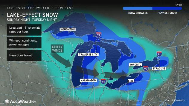
Several parts of Ontario are bracing for a historic lake-effect snowstorm, with predictions of “incredible snow totals” over the next few days. This significant weather event is a result of a dramatic temperature shift over the Great Lakes, a phenomenon Global News meteorologist Anthony Farnell attributes to unusually mild water temperatures for this time of year. These record-mild lake temperatures, a consequence of the calm fall, are creating “ideal conditions” for a massive lake-effect snow event.
The Snow Squall Warning: Timing and Intensity
Farnell predicts that areas downwind of all five Great Lakes will experience substantial snowfall this weekend, with travel conditions described as “difficult at best.” The Lake Huron and Georgian Bay snow squalls are expected to intensify rapidly early Friday morning, persisting into early next week. While areas close to the lakes may initially see heavier, wetter snow due to the mild water temperatures, the wind shifts will redistribute the snow, leading to varying accumulations across different communities.
Predicting the Unpredictable: Variability in Snowfall
The intensity of these snow squalls is nothing short of remarkable; in the most intense periods, snowfall rates could reach as high as eight centimeters per hour, accompanied by thunder and lightning. By Monday, cumulative snowfall could reach a staggering 80 centimeters in areas experiencing persistent snow squalls. While much of the Greater Toronto Area (GTA) is projected to avoid the heaviest snowfall, parts of the north and west end might see accumulations exceeding 10 centimeters by Monday. Toronto itself is likely to experience only light snow flurries, with minimal accumulation.
Environment Canada's Warnings and Watches
Environment Canada has issued numerous winter weather warnings and watches across southern Ontario. Snow squall warnings are currently in effect for areas surrounding Owen Sound, Blue Mountains, Bracebridge, Parry Sound, Huntsville, Sault Ste. Marie, and regions further north near Lake Nipigon. The warnings also extend to areas north of Waterloo, including North Perth, Huron East, Grand Valley, and Orangeville, as well as Manitoulin Island, Elliot Lake, and Bayfield Inlet. This widespread alert highlights the severity and broad reach of the impending snowstorm.
School Closures and Travel Advisories
Given the intensity and duration of the predicted snowfall, school bus cancellations and even school closures are highly probable in many affected areas. School boards in Muskoka (TLDSB), Parry Sound (NNDSB), and the Bruce Peninsula (BWDSB) are considered almost certain to experience cancellations on Friday. There’s also a strong likelihood (75%) of cancellations in Southampton and Kincardine (BWDSB) and East Parry Sound (NNDSB). The probability decreases for other areas, but the possibility of localized cancellations remains, depending on the shifting conditions. Drivers are urged to exercise extreme caution and check for road closures before attempting to travel.
Impact on Different Regions: A Closer Look
A multi-day snow squall event is anticipated to begin Thursday evening, primarily affecting regions east of Lake Huron and Georgian Bay. Intense snowfall exceeding 5 centimeters per hour, coupled with near-zero visibility, is forecast, making travel extremely hazardous throughout Friday and the weekend. Environment Canada's warnings underscore the potential for significant road closures. Areas such as Bracebridge, Gravenhurst, Huntsville, Haliburton, Owen Sound, and Tobermory are expected to bear the brunt of the storm. The forecast highlights the potential for highly variable snowfall amounts, with some areas receiving well over 50 centimeters by Sunday.
Beyond the Snowbelt: Impacts on GTA and Surrounding Areas
While the most significant impacts are concentrated in the traditional snowbelt regions, there is a possibility of localized snowfall in other areas, including London, Guelph, and parts of the GTA. The intensity of these impacts remains uncertain and dependent on the precise path and strength of the snow squalls. The potential for impacts to the GTA and Highway 401 depends on localized strong squalls, with higher confidence in snow predictions north of Toronto towards Kingston. Meanwhile, places like London, Guelph, Barrie, and parts of Highway 400 have several chances for snow squall activity. The message for these regions is to remain weather-aware and ready for rapidly changing conditions. The possibility of significant snow for the GTA and surrounding regions remains a developing story.
Preparing for the Blizzard: Essential Tips
With the potential for hazardous conditions, including road closures and power outages, it's imperative to prepare. Ensure your vehicle is winter-ready, with snow tires, an emergency kit, and a full tank of gas. Check weather forecasts regularly and heed travel advisories from authorities. Stay informed about potential school closures or bus cancellations. Remember, safety should be the top priority during this significant weather event. By remaining vigilant and prepared, we can navigate this powerful snowstorm safely and minimize its impact on our daily lives.


