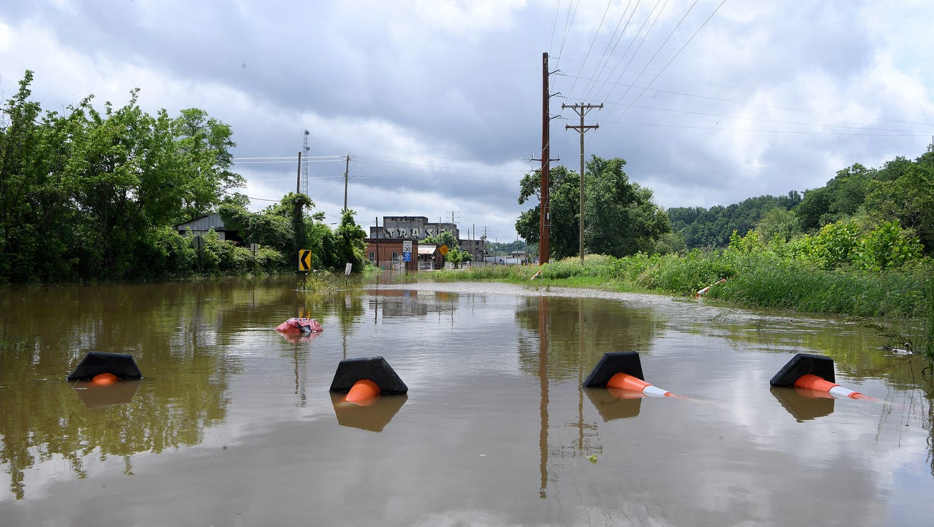
Though Hurricane Helene has now been downgraded to a tropical storm, its path toward WNC has left outages, flooding and landslides in its wake. Flooding in Buncombe County and surrounding areas of Western North Carolina has led to mandatory evacuation orders as rivers overflow past spillways. Here's what we know about flooding at the French Broad and Swannanoa rivers associated with several evacuation orders.
NOAA and USGS river gauges show flooding in WNC river basins. The Flood stage begins at 9.5 feet, considered minor flooding. 13 feet is considered moderate flooding, while 18 feet is considered major flooding.
River Levels and Flood Predictions
- French Broad at Asheville: 13.75 feet as of 7:45 a.m. Predicted to peak at 21 feet at 8 p.m.
- French Broad at Fletcher: 20.35 feet as of 8:15 a.m. Predicted to peak at a record-breaking 30.5 feet at 8 p.m.
- French Broad River near Marshall: 12.21 feet as of 8 a.m. Predicted to peak at 19 feet at 8 p.m.
- Swannanoa River at Biltmore: 17.72 feet as of 8:30 a.m. Predicted to peak at 21 feet at 2 p.m.
- French Broad River at Rosman (USGS): 13.38 feet at 8:30 a.m.
Evacuation Orders and Shelter Information
Mandatory evacuations are underway in several areas due to flooding. Waters at the North Fork Reservoir have gone over the spillway, leading Buncombe County to order mandatory evacuation for residents in the following areas:
- Swannanoa River Valley area: All residents downstream of the reservoir are required to move to higher ground. Shelter is available at Harrah's Cherokee Center Asheville (87 Haywood St, Asheville, NC 28801). Explore Asheville has worked with local hotels to make rooms available for residents who are seeking shelter from the storm.
- 105 Balsam Road: From the camp south to U.S. 70 in Black Mountain due to flooding of a lake with a dam at Camp Ridgecrest for Girls.
Emergency Response and Road Closures
The Haywood County sheriff said to consider all of the county roads closed until further notice due to flooding. Emergency management officials in McDowell County urged residents living near creeks, rivers, and streams at high risk of flash flooding to evacuate. The city of Hendersonville has upgraded its Flood Response Plan to a Flood Level 4 (Extensive Flooding), urging residents living in the 500-year floodplain to prepare to evacuate if necessary.
Weather Impacts and Power Outages
Hundreds of thousands of people in western North Carolina are without power due to downed trees and power lines. Duke Energy reported over 71,000 outages in Buncombe County and 42,000 in Henderson County. The Asheville Regional Airport set back-to-back daily rainfall records on Wednesday and Thursday, and is likely to set a third consecutive one on Friday. September 2024 is now the wettest September on record in Asheville, with over 14" of rain and counting.
Helene's Path and Impacts
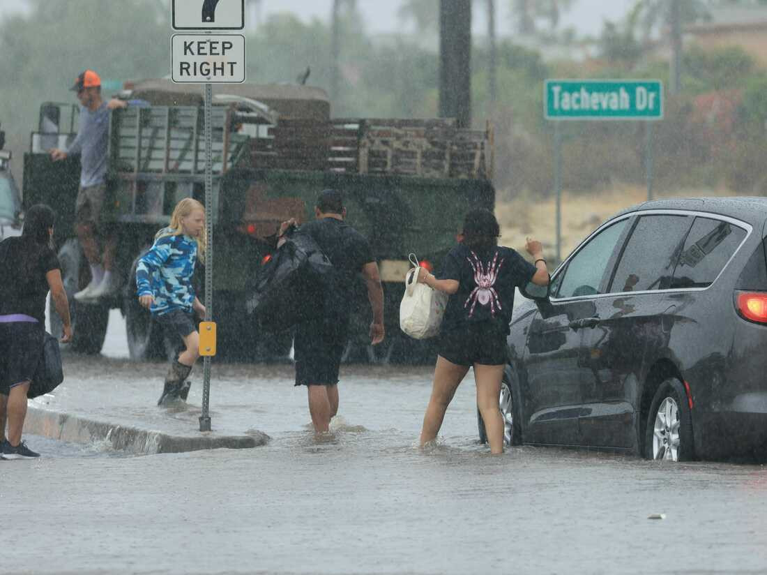
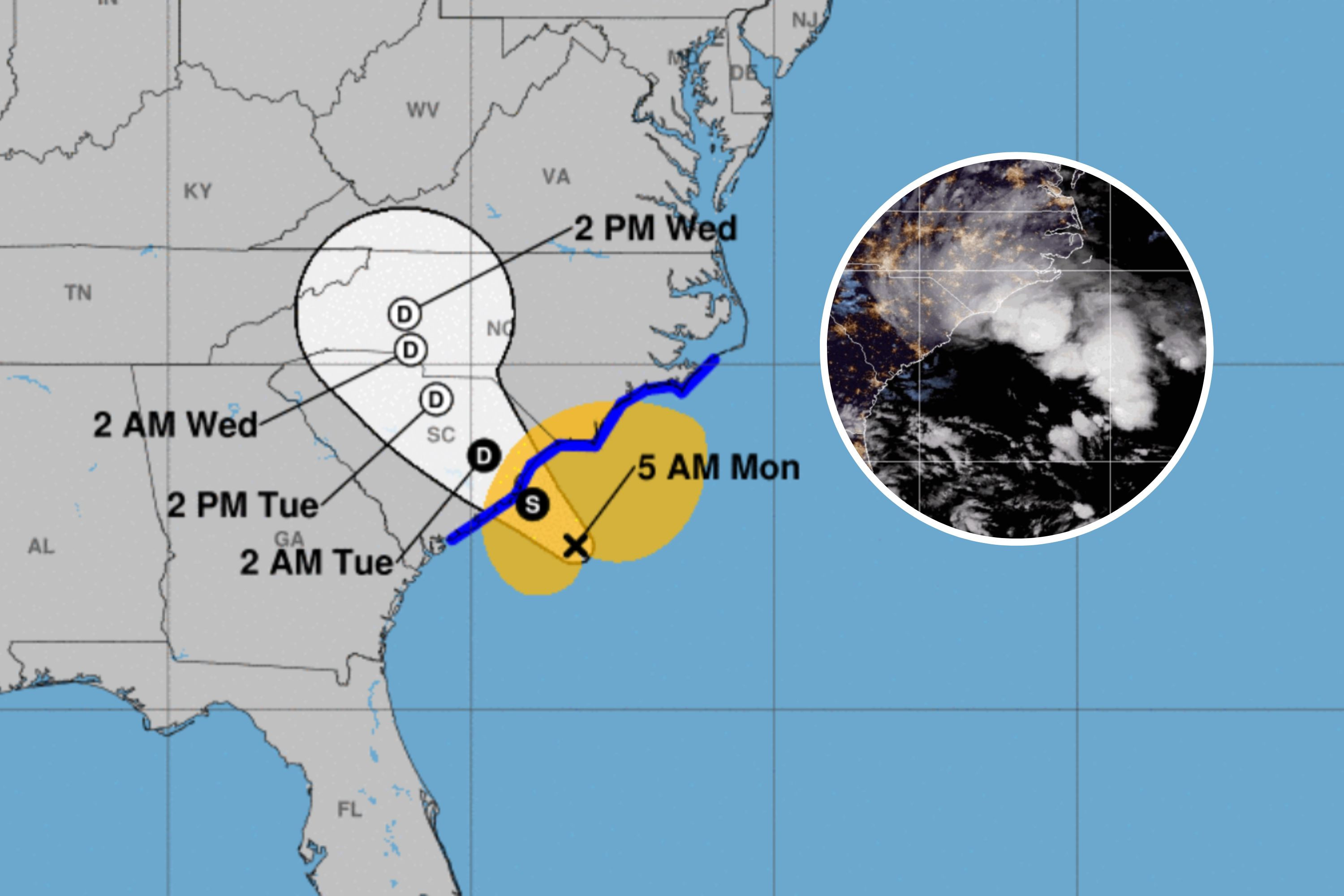
Tropical Storm Helene is tracking inland over the Southeast today with extreme flash flooding, record river flooding, damaging winds and tornadoes. Helene made landfall at 11:10 p.m. EDT Thursday night about 10 miles west-southwest of Perry, Florida, as Category 4 packing 140-mph winds. The tropical storm is now centered 105 miles north-northeast of Atlanta, and is tracking quickly northward at 32 mph. Maximum sustained winds are 45 mph.
Widespread Flooding and Record River Levels
Numerous flash flood warnings are ongoing, as shown by the green outlines on the radar map below. Several of the warnings this morning have been high-end flash flood emergencies in western North Carolina, including Asheville, upstate South Carolina, eastern Tennessee, southwest Virginia and northern Georgia, including Atlanta. That means serious flooding impacts have occurred in those areas. Record flood crests have been observed on multiple rivers in North Carolina, including the Pigeon River in Canton, French Broad River in Fletcher and the Swannanoa River at Biltmore (near Asheville). Rainfall totals have topped a foot in parts of Florida, Georgia, North Carolina and South Carolina since Wednesday. The top total is nearly 30 inches near Busick, North Carolina. The greatest flood threat Friday continues to be from northern Georgia into the the southern Appalachians. Rainfall from Helene has already triggered catastrophic flooding in this region. That's because the heavy rain in addition to the hilly and mountainous terrain is a prime setup for destructive, life-threatening rainfall flooding and landslides. Major to locally record flooding is possible on some rivers.
High Winds and Tornado Threat
Tropical storm warnings remain posted from parts of Georgia into South Carolina and western North Carolina. The National Weather Service has also posted high wind warnings and wind advisories in the Ohio, Tennessee and mid-Mississippi valleys. Additional downed trees and power outages could impact these areas today into tonight. Earlier this morning, wind gusts over 90 mph were clocked in south Georgia, including near Valdosta, Alma and Douglas. A wind gust as high as 82 mph has been measured as far north as Augusta, Georgia. Many landfalling hurricanes also produce a tornado threat to the right, or in this case east, of where the center tracks. The greatest chance of a few tornadoes today is in the eastern Carolinas and southern Virginia.
Helene's Formation and Landfall
The need to issue tropical storm warnings and hurricane watches for western Cuba and Mexico's Yucatan Peninsula prompted the NHC to begin advisories on Potential Tropical Cyclone Nine in the western Caribbean Sea on Sept. 23. The following morning, Tropical Storm Helene formed as bands of rain and strong winds lashed Cancún and Cozumel. Helene also produced heavy rain and some tropical storm force gusts over parts of western Cuba. Helene then became a hurricane over the southern Gulf of Mexico on Sept. 25, then rapidly intensified into a Category 4 hurricane in the evening before landfall on Sept. 26. Helene became the second major hurricane of the 2024 Atlantic hurricane season Thursday afternoon. Early in the evening, a NOAA Hurricane Hunter mission found maximum winds had increased Category 4 intensity. Helene's center moved ashore around 11:10 p.m. EDT Thursday night about 10 miles west-southwest of Perry, Florida, with winds of 140 mph, Category 4 intensity, and a pressure of 938 millibars, according to the National Hurricane Center.
Helene's Record-Breaking Intensity
Helene is the strongest hurricane on record to landfall in Florida's Big Bend region, stronger than 2023's Idalia, which made a Category 3 landfall with 115 mph winds and a pressure of 950 millibars and an 1896 Cedar Keys hurricane's 125 mph winds. Helene is also the third hurricane to landfall in Florida's Big Bend region in just under 13 months. Three of the last five hurricanes to landfall in the mainland U.S. have done so in this Big Bend region.
Helene's Impacts in Florida
Landfall storm reports: The eyewall, home to a hurricane's most intense winds, prompted a rare "extreme wind warning," a high-end alert only issued for Category 3 or stronger hurricane eyewalls to alert those in the path to take shelter from these damaging winds as if a tornado warning was issued. Peak storm surge is estimated to have reached more than 15 feet in the Florida Big Bend region based on post-storm modeling. The area will be surveyed at a later time to reveal the actual measured storm surge heights. Over 9 feet of inundation was reported by a gauge at Cedar Key, Florida, much higher than that from Hurricane Idalia in August 2023 (6.84 feet). Surge flooding in parts of the Tampa Bay area topped previous modern era records from 2023's Idalia or earlier. Clearwater Beach reported about 6.7 feet of inundation (above average high tide), easily surpassing its previous record from the March 1993 Superstorm (4.02 feet). The St. Petersburg gauge - about 6.31 feet of inundation - also crushed its previous modern-era record from 1985's Hurricane Elena. Significant flooding was also reported at Ft. Myers Beach and Naples, where gauges measured 4 to 5 feet of surge inundation. According to a ham radio operator, water 5 to 6 feet above normal levels was observed in the Punta Gorda Canal Network. Winds gusted to 98 mph at Perry, 84 mph at Cedar Key and 82 mph at St. Petersburg's Albert Whitted Airport. Gusts up to 72 mph at Miami's Opa Locka Airport, 70 mph in Sarasota and 67 mph in Orlando were also recorded.
Staying Informed
Visit your area's NWS forecast page for specific information on tropical storm warnings and flood advisories. Stay tuned to local news outlets for the latest updates on evacuations, road closures, and power outages.